Strathcona Provincial Park, Phillips Ridge Trail and Elk River Trail - July 21-23, 2020
Vancouver Island, British Columbia, Canada

Jul 25, 2020
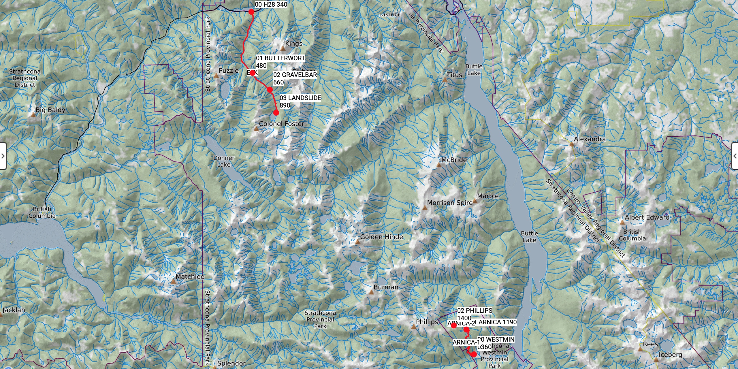
I returned from a three-day solo mission into the heart of Strathcona Park. My original objective was to camp two nights at Arnica Lake and survey terrain for future trips on the Golden Hinde Traverse and around the Phillips Ridge Horseshoe. My actual trip expanded into two separate adventures along both ends of the Golden Hinde Traverse. Day one, I hiked up the Phillips Ridge Trail to Arnica Lake for my first night. I explored Phillips Ridge for a couple of kilometres beyond the lake. Day two, I descended back to the mine site and drove up Buttle Lake to the Elk River Trailhead. I backpacked into Butterwort Camp for my second night. Day three, I hiked up to Landslide Lake and back out to the trailhead. Highlights included near perfect weather, surveying new terrain, and an early morning viewing of a mother black bear and her two cubs walking along the shoreline of Arnica Lake.
Weather (Data logged with Kestrel Weather and Environmental Meters Drop D3)
The forecast was for mainly sunny skies, a zero to low probability of precipitation, and warm temperatures with a cooling trend. Day one and two were the hottest and buggiest. Day three was perfect with nice temperatures and no bugs.
- Day 1, 1130 h, Phillips Ridge Trailhead, 360 m, no clouds, no precipitation, temperature 21.6ºC, humidity 56.5%, wind calm. 1500 h, Arnica Lake Camp, 1200 m, few clouds, no precipitation, temperature 25.4ºC, humidity 43.2%, wind calm. 2000 h, Arnica Lake Camp, 1200 m, partially cloudy, no precipitation, temperature 19.6ºC, humidity 74.7%, wind calm.
- Day 2, 0800 h, Arnica Lake Camp, 1200 m, cloudy, no precipitation, temperature 15.0ºC, humidity 90.0%, wind light S. 1145 h, Phillips Ridge Trailhead, 360 m, partially cloudy, no precipitation, temperature 24.6°C, humidity 55.9%, wind calm. 1415 h, Elk River Trailhead, 340 m, cloudy, no precipitation, temperature 24.0°C, humidity 54.9%, wind calm. 1800 h, Butterwort Camp, 480 m, partially cloudy, no precipitation, temperature 21.2°C, humidity 65.6%, wind calm.
- Day 3, 0700 h, Butterwort Camp, 480 m, no clouds, no precipitation, temperature 10.1°C, humidity 96.8%, wind calm. 1000 h, Landslide Lake, 900 m, no clouds, no precipitation, temperature 16.7°C, humidity 73.4%, wind calm.
Route (Data logged with Suunto 9 Baro and Suunto App)
The Phillips Ridge Trail starts with well-engineered switchbacks all the way to Arnica Lake. There are three signed water fills at 500 m, 700 m, and 1050 m. The trail then meanders through subalpine meadows and tarns gently up onto Phillips Ridge. The terrain opens up at 1400 m with spectacular vistas in all directions. The Elk River Trail is a valley bottom hike below some of Vancouver Island’s highest summits. There is a slight elevation gain to Butterwort Camp at 6 km. The terrain gets rougher and steeper up to the Gravel bar Camp at 9 km. The trail travels exposed bedrock to the edge of Landslide Lake. The north shore offers the best views of Mount Colonel Foster to the southwest and Elkhorn Mountain to the northeast. There is the option to continue along the east shore of Landslide Lake up to Berg Lake.
- Day 1, Phillips Ridge Trailhead (360 m, GR 114947) to Arnica Lake Camp (1200 m, GR 108968). Distance: 7.00 km, Duration: 3:19’49, Ascent 834 m, Ascent Time: 2:40’25, Descent: 18 m, Descent Time: 05’16.0. Arnica Lake Camp (1200 m, GR 108968) to Phillips Ridge (1410 m, GR 097972). Distance: 4.60 km, Duration: 2:00'08, Ascent 236 m, Ascent Time: 49’46.0, Descent: 234 m, Descent Time: 44’31.0.
- Day 2, Arnica Lake Camp (1200 m, GR 108968) to Phillips Ridge Trailhead (360 m, GR 114947). Distance: 6.95 km, Duration: 2:36’51, Ascent 6 m, Ascent Time: 02’52.0, Descent: 830 m, Descent Time: 2:02’10. Elk River Trailhead (340 m, GR 933247) to Butterwort Camp (480 m, GR 932194). Distance: 6.68 km, Duration: 2:06’08, Ascent 217 m, Ascent Time: 1:08’37, Descent: 90 m, Descent Time: 20’13.0.
- Day 3, Butterwort Camp (480 m, GR 932194) to Landslide Lake (900 m, GR 951160). Distance: 4.89 km, Duration: 1:50’23, Ascent 461 m, Ascent Time: 1:22’53, Descent: 44 m, Descent Time: 10’36.0. Landslide Lake (900 m, GR 951160) to Elk River Trailhead (340 m, GR 933247). Distance: 10.87 km, Duration: 3:16’59, Ascent 112 m, Ascent Time: 26’46.0, Descent: 677 m, Descent Time: 2:11’56.
Wildlife
The best wildlife viewing was a mother black bear walking with her two cubs along the shoreline of Arnica Lake on day two. Mom was digging under deadfall looking for grubs. The two cubs were zig-zagging and bouncing around. I was separated from my tent (and my camera) when I first saw them. They appeared to be headed towards camp. I got back to my tent quickly and grabbed my backpack and bear spray. By that time I had lost sight of them, but could hear them crashing around the bushes behind camp. I waited patiently on a high point, hoping to see them again. However, they departed toward the route onto Phillips Ridge where I was the evening before. I asked my neighbours if they saw the bears when they popped out of their tent 30 minutes later and they said “What bears?” Apparently they heard the crashing but thought it was me! Other wildlife of note were the clouds of mosquitoes and black flies around Arnica Lake and on Phillips Ridge. Lots of birds live in that zone, including hermit thrushes, varied thrushes, Pacific wrens, an unidentified woodpecker, and hummingbirds. There were almost no bugs on the Elk River Trail. I enjoyed watching dozens of dragonflies eating them up above my camp at Butterwort.
Hazards
Besides the bugs, hazards were limited to the heavy industrial traffic at the mine site. Sun exposure, heat exhaustion, and dehydration were all considered and mitigated with sun protection, ample fluids, and electrolytes.
Notes
The Phillips Ridge Trail offers efficient access up to Arnica Lake and beyond to Phillips Ridge. The active mining operations and constant hum take away from the wilderness experience until up on Phillips Ridge where it’s easy to forget about it. Unfortunately, there are no BC Parks amenities at Arnica Lake beside three wooden tent pads. No outhouse, no food cache, and one small “No Campfires” sign. This zone could benefit from more infrastructure. There were at least a couple of dozen hikers and a few dogs headed up when I was heading down. Where is everyone going to the bathroom? Would a food cache be a smart addition where there are tent pads and known bear activity around them? The Elk River Trail is located in one of three Strathcona Core Areas. There are amenities at both official campsites, including outhouses, food caches, and plenty of signs encouraging no campfires and leave no trace practices. The next objective is to connect these two hikes from end to end. I would prefer to hike southbound starting in the more pristine Elk River Valley and finishing with Phillips Ridge and down to the mine.
Mike Blake
ACMG HG
mbguiding.ca