Strathcona Provincial Park, Moat Lake Circuit - Sep 2-4, 2020
Vancouver Island, British Columbia, Canada

Sep 7, 2020
We completed a three-day backpacking trip into the Forbidden Plateau core zone of Strathcona Provincial Park. Our objectives linked two nights at Circlet Lake basecamp with a challenging day-hike on the Moat Lake Circuit. Highlights included near perfect weather and route conditions, low bug pressure, and epic views of the Strathcona alpine.
Weather (Data logged with Kestrel Weather and Environmental Meters Drop D3)
The forecast was for sunny skies and warm temperatures for all three days. The heat contributed to a few clouds forming above the mountains during the days, occasionally obscuring the peaks. Temperatures cooled down in the evenings and mornings were clear.
- Day 1, 1430 h, Paradise Meadows Trailhead, 1090 m, few clouds, no precipitation, temperature 21.2ºC, humidity 57.2%, wind calm. 1900 h, Circlet Lake Camp, 1190 m, few clouds, no precipitation, temperature 17.6ºC, humidity 65.4%, wind calm.
- Day 2, 0730 h, Circlet Lake Camp, 1190 m, few clouds, no precipitation, temperature 10.0ºC, humidity 100.0%, wind calm. 1200 h, Castlecrag Mountain, 1765 m, obscured, no precipitation, temperature 19.8°C, humidity 76.3%, wind light NW. 1400 h, Mount Frink, 1950 m, few clouds, no precipitation, temperature 24.4°C, humidity 48.1%, wind calm. 17.6 h, McPhee Lake, 1170 m, few clouds, no precipitation, temperature 10.0ºC, humidity 75.4%, wind calm.
- Day 3, 0900 h, Circlet Lake Camp, 1190 m, no clouds, no precipitation, temperature 14.7ºC, humidity 80.2%, wind calm. 1430 h, Paradise Meadows Trailhead, 1090 m, few clouds, no precipitation, temperature 24.4ºC, humidity 55.9%, wind calm.
Route (Data logged with Suunto 9 Baro and Suunto App)
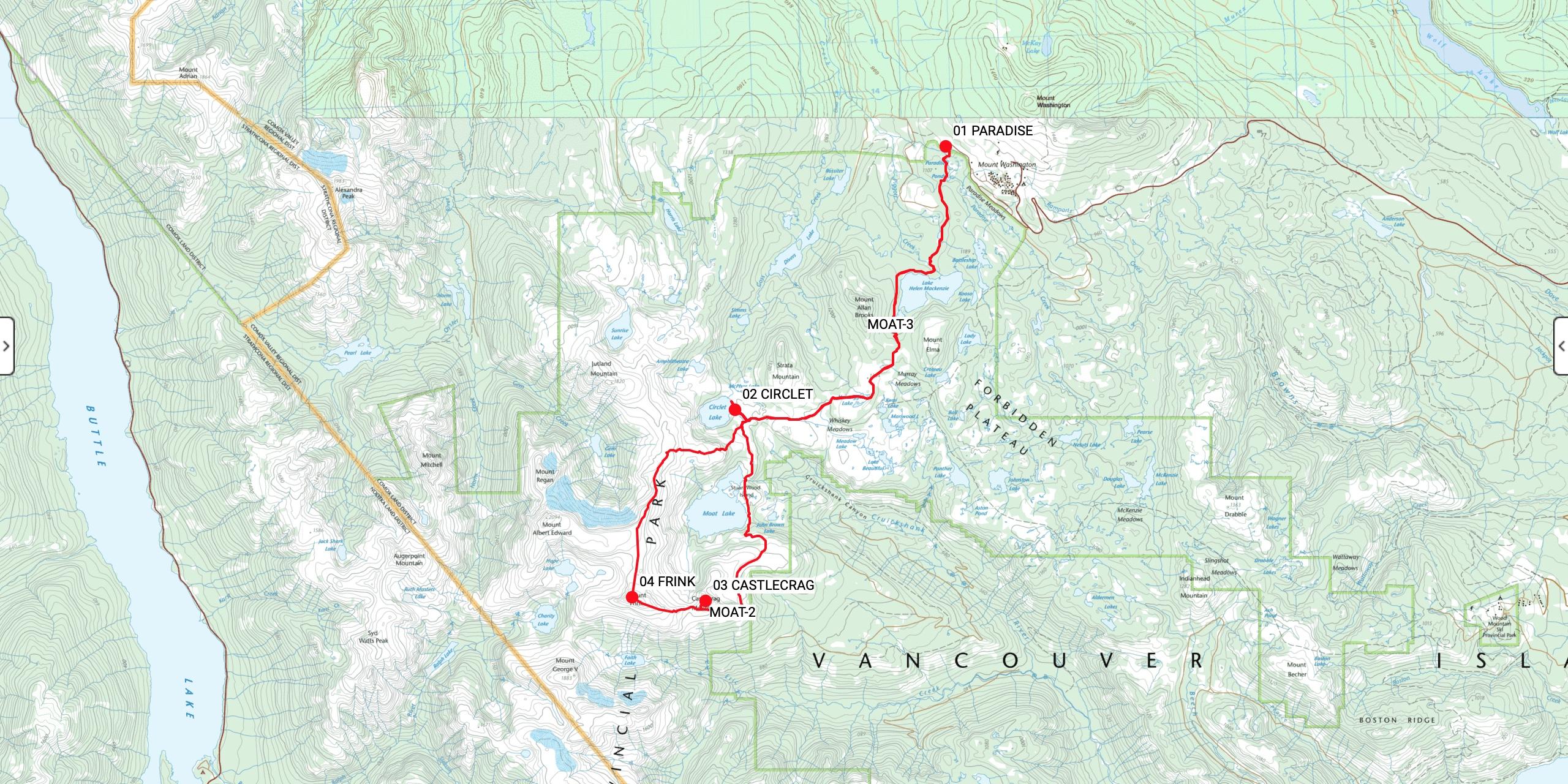
The Paradise Meadows Trailhead offers efficient access to the subalpine. The trail meanders SW towards Circlet Lake through a mixture of gravel paths, boardwalks, bridges, lakeshore, muddy roots, old-growth forest, steep slopes, flat meadows, and wet creek beds. The Moat Lake Circuit continues past Circlet Lake and includes a mixture of rocky plateaus, ramps, steep gullies, talus slopes, boulder fields, and seasonal snow patches.
- Day 1, Paradise Meadows Trailhead (1090 m, GR 328128) to Circlet Lake Camp (1190 m, GR 284076). Distance: 11.13 km, Duration: 4:05’42, Ascent 460 m, Ascent Time: 1:38’30, Descent: 369 m, Descent Time: 1:37’16.
- Day 2, Circlet Lake Camp (1190 m, GR 284076) to Castlecrag Mountain (1765 m, GR 277038) to Mount Frink (1950 m, GR 262039) to Circlet Lake Camp. (1190 m, GR 284076). Distance: 16.05 km, Duration: 10:56, Ascent 1376 m, Ascent Time: 3:18’54, Descent: 1389 m, Descent Time: 4:04’35.
- Day 3, Circlet Lake Camp (1190 m, GR 284076) to Paradise Meadows Trailhead (1090 m, GR 328128). Distance: 10.92 km, Duration: 4:07’58, Ascent 309 m, Ascent Time: 1:22’32, Descent: 429 m, Descent Time: 1:41’02.
Wildlife
No mega fauna sign or sightings. Wildlife viewing was limited to birds, bugs, and flowers. We watched two pairs of ravens perform aerial acrobatics from the summit of Mount Frink. Swallows hunted bugs above our heads. We shared camp with a tiny brown Pacific wren and a noisy chipmunk. Canadian jays followed us in the meadows and descended nearby whenever we stopped for a break.
Hazards
Sun exposure and dehydration were our main concerns. We drank throughout the day, re-applied sunscreen regularly, wore brimmed hats, and took breaks in the shade. Water sources were adequate with multiple tarns on our route. The route down Castlecrag Mountain’s SW ridge towards Mount Frink has a few sections of steep and exposed terrain. There are steep and slippery sections on the descent from Mount Albert Edward to Circlet Lake. There have been many search and rescues from this zone over the years. BC Parks installed brand new navigation aids on the Albert Edward/Jutland Col. Six tall metal poles with reflectors on the top help point hiker traffic down the route towards Circlet Lake. These poles would still be tricky to find in zero visibility conditions. Strong wilderness navigation skills and accurate route-finding techniques are essential for the Moat Lake Circuit.
Notes
We departed Circlet Lake on the Friday morning before Labour Day long weekend. We passed dozens of hikers and backpackers walking in and loaded down with gear. BC Parks has worked hard to increase the infrastructure of Circlet Lake Camp. New tent pads and outhouses have expanded the facility. We have no doubt that the weekend was still crowded and busy. Mid-week always offers a quieter experience if you can make that schedule work.