Strathcona Provincial Park, Moat Lake Circuit - July 6-8, 2020
Vancouver Island, British Columbia, Canada

Jul 9, 2020
I returned from my third solo training and reconnaissance mission into the backcountry of Strathcona Park. The Moat Lake Circuit is a premier subalpine to alpine trek in the Forbidden Plateau Core Area. My objective was to spend two nights camping at Circlet Lake and day hike the circuit around Moat Lake. This is a challenging route that requires advanced hiking experience and excellent wilderness navigation skills. The low cloud ceiling that hung over the Strathcona alpine and the lingering snowpack added to terrain management challenges. Bring navigation tools (map, compass, GPS, backup power, brain) and know how to use them.
Weather (Data logged with Kestrel Weather and Environmental Meters Drop D3)
The forecast was for overcast skies with cool temperatures and a low probability of precipitation. The weather on day one was the same as predicted. On day two, I started hiking the circuit in the fog. I made my summit in the clouds and then got lucky with a momentary broken sky. The clouds dropped down again overnight and obscured everything until arriving at the parking lot later in the morning of day three.
- Day 1, 1400 h, Paradise Meadows Trailhead, 1095 m, overcast sky, no precipitation, temperature 13.1ºC, humidity 67.8%, wind calm. 1800 h, Circlet Lake Camp, 1200 m, overcast sky, no precipitation, temperature 12.0ºC, humidity 80.1%, wind calm.
- Day 2, 0600 h, Circlet Lake Camp, 1200 m, obscured sky, no precipitation, temperature 6.8ºC, humidity 100.0%, wind calm. 1115 h, Mount Frink Summit, 1935 m, obscured skies, no precipitation, temperature 8.7°C, humidity 93.7%, wind light W. 1800 h, Circlet Lake Camp, 1200 m, broken clouds, no precipitation, temperature 10.1ºC, humidity 84.2%, wind calm.
- Day 3, 0600 h, Circlet Lake Camp, 1200 m, obscured sky, no precipitation, temperature 6.6ºC, humidity 100.0%, wind calm. 0940 h, Paradise Meadows Trailhead, 1095 m, overcast sky, no precipitation, temperature 11.5ºC, humidity 99.2%, wind calm.
Route (Data logged with Suunto 9 Baro and Suunto App)
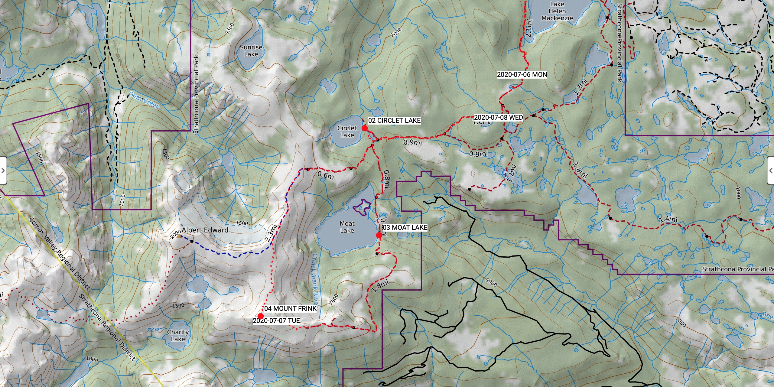
The Paradise Meadows Trailhead (1095 m, GR 329128) is one of the most easily accessible in all of Strathcona Park. The paved Strathcona Parkway whisks you up the 1000 vertical metres to the subalpine over 20 km in 25 min from Highway 19. The trail from the parking lot is double wide and wheelchair accessible for the first 900 m over gravel and boardwalks. The trail then transitions into single track over dirt and roots with more boardwalk and stair sections up to Lake Helen Mackenzie (GR 323102). The trail gets rougher (lots of rocks and roots) and muddier along the NW shore of the lake before climbing up to the plateau by the BC Parks Ranger Cabin (no rangers). The next section includes rolling single track and boardwalk through beautiful subalpine meadows all the way to Circlet Lake (1200 m, GR 284076). The clockwise circuit around Moat Lake (1175 m, GR 286054) begins with rough single track and bushy sections all the way up the NW shoulder of Castlecrag Mountain. There is a challenging crossing over large boulders in the landslide debris below Castlecrag (1415 m, GR 284038). Once up and beyond Castlecrag, the route gets tricky to follow in places that are still covered in seasonal snow. Any random cairns and flags should not to be relied on. The summit of Mount Frink (1950 m, GR 261039) usually offers fine views of the Strathcona alpine to the north, west, and south. Not on this trip though. The route off Mount Frink towards the Albert Edward/Frink col (1820 m, GR 263043) is on steep rocky ribs and snow fields with excellent conditions for glissading. I took the tight line along the ridge above Moat Lake towards the Mount Albert Edward mainline. Once linked up with the main trail, there are cairns galore and a fairly wide track down to the Albert Edward/Jutland col (1620 m, GR 270068). The route back down to Circlet Lake is fairly steep in places but pretty easy to follow. The hike back out from Circlet Lake to the Paradise Meadows Trailhead is a reverse of the way in. There are options for side trips, including two more summits on the circuit that I skipped due to poor visibility: Mount Albert Edward (2093 m, GR 245055) and Castlecrag Mountain (1765 m, GR 277038).
- Day 1, Paradise Meadows Trailhead (1095 m, GR 329128) to Circlet Lake (1200 m, GR 284076). Distance: 10.61 km, Duration: 2:53'20, Ascent 391 m, Ascent Time: 1:19’22, Descent: 289 m, Descent Time: 1:12’15.
- Day 2, Circlet Lake to Circlet Lake (1200 m, GR 284076) via Mount Frink (1950 m, GR 261039). Distance: 15.20 km, Duration: 7:27’28, Ascent 1093 m, Ascent Time: 3:00’02, Descent: 1084 m, Descent Time: 3:01’05.
- Day 3, Circlet Lake (1200 m, GR 284076) to Paradise Meadows Trailhead (1095 m, GR 329128). Distance: 10:53 km, Duration: 2:50’57, Ascent: 289 m, Ascent Time: 1:12’10, Descent: 403 m, Descent Time: 1:14’02.
Wildlife
No mega fauna sign or viewing. I heard an endangered Vancouver Island marmot whistling on the south side of Castlecrag Mountain. Three separate ptarmigan sightings all changing into their summer colours, including one with chicks. Other bird viewing included numerous fat whisky jacks, varied thrushes, hermit thrushes, Pacific wren, and a surprise encounter with a grouse. No-see-ums were abundant at times, but otherwise bug pressure seemed low for this time of year.
Hazards
Hazards included slippery boardwalks between Paradise Meadows and Lake Helen Mackenzie. Slippery roots, rocks, hard clay, and mud is everywhere else. Snow patches started above 1450 m. Some steep exposed snowy sections between Castlecrag and Frink were avoided by rerouting along the adjacent rocks. White-out navigation skills are essential on this route.
Notes
The Moat Lake Circuit is one of my favourite three day / two night trips in Strathcona Park. Easy and efficient access to the subalpine trailhead, plus well-used and managed trail networks make this zone a hiker’s dream. The new Circlet Lake construction site is the biggest BC Parks renovation project I have ever seen: 60 new tent pads, three new environmentally friendly outhouses, kitchen sinks, and double wide food caches. I had the pleasure of meeting and chatting with a fellow ACMG colleague at the campground on my first night. We were amongst only a handful of campers with empty tent pads all around us. Hats off to BC Parks for investing in and renovating this high-capacity campground.
Mike Blake
ACMG HG
mbguiding.ca