Strathcona Provincial Park, Flower Ridge Trail - August 4-6, 2020
Vancouver Island, British Columbia, Canada

Aug 8, 2020
I returned from a three-day backpacking trip along the Flower Ridge Trail in Strathcona Park. My objective was two nights on the ridge with an exploratory day hike towards the headwaters of Price Creek and Henshaw Creek. Highlights included great weather and route conditions, low bug pressure, and spectacular views. The only downside of the trip was the abundance of exposed toilet paper beside one of the popular campsites.
Weather (Data logged with Kestrel Weather and Environmental Meters Drop D3)
The forecast was for sunny skies on days one and two, and clouds with precipitation on day three. Days one and two were warm, dry, and calm. Day three was foggy and cool, with light precipitation below the clouds.
- Day 1, 0430 h, Flower Ridge Trailhead, 240 m, few clouds, no precipitation, temperature 14.6ºC, humidity 79.1%, wind calm. 1200 h, Pond Camp, 1385 m, partially cloudy, no precipitation, temperature 17.7ºC, humidity 54.3%, wind calm. 1800 h, Pond Camp, 1385 m, partially cloudy, no precipitation, temperature 22.7ºC, humidity 46.3%, wind calm.
- Day 2, 0600 h, Pond Camp, 1385 m, no clouds, no precipitation, temperature 9.5ºC, humidity 100.0%, wind calm. 1200 h, Swim Pond, 1360 m, partially cloudy, no precipitation, temperature 23.0°C, humidity 47.6%, wind calm. 1600 h, Pond Camp, 1385 m, cloudy, no precipitation, temperature 18.8°C, humidity 58.9%, wind calm.
- Day 3, 0700 h, Pond Camp, 1385 m, obscured, no precipitation, temperature 6.4°C, humidity 100.0%, wind light W. 0900 h, Ridge Tarn, 1275 m, obscured, light rain, temperature 8.6°C, humidity 100.0%, wind calm. 1115 h, Flower Ridge Trailhead, 240 m, cloudy, no precipitation, 13.2ºC, humidity 100.0%, wind calm.
Route (Data logged with Suunto 9 Baro and Suunto App)
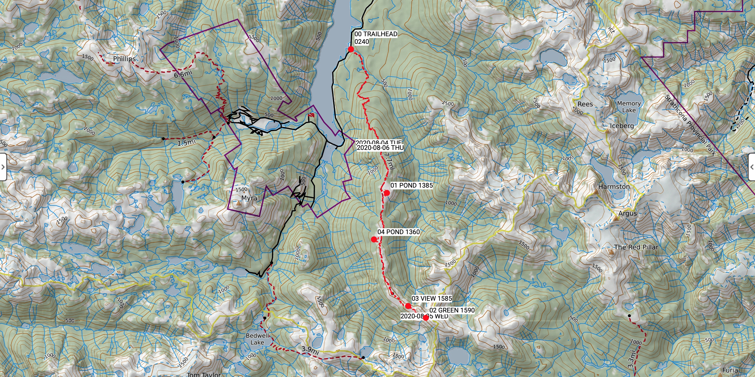
The Flower Ridge Trail offers efficient access to the subalpine. The old trail has a gentle gradient rising 1100 m over 8 km. The trail meanders up through old growth forest along a series of small ridges and benches. There are a few steeper sections before entering a beautiful open slope of meadows onto the north end of the ridge. Once on Flower Ridge, hikers are rewarded with sweeping views of surrounding mountains and Buttle Lake. A series of bumps dotted with ponds every couple of kilometres offers excellent camping opportunities. I camped at a small pond 200 m east of the mainline (GR 177194). The ridge continues for another four kilometres until reaching a bump at the official end of maintained trail (GR 178872). The backcountry route begins with a worn tread toward the headwaters of Price Creek and Henshaw Creek. I turned around at the viewpoint above Green Lake (GR 192861) and did not enter the scrambling terrain.
- Day 1, Flower Ridge Trailhead (240 m, GR 164975) to Pond Camp (1385 m, GR 177914). Distance: 8.73 km, Duration: 3:46'21, Ascent 1307 m, Ascent Time: 2:51’18, Descent: 159 m, Descent Time: 26’30.0.
- Day 2, Pond Camp (1385 m, GR 177914) to Green Lake Viewpoint (1590 m, GR 192861) return. Distance: 15.95 km, Duration: 6:47'09, Ascent 832 m, Ascent Time: 2:51’55, Descent: 831 m, Descent Time: 2:37’53.
- Day 3, Pond Camp (1385 m, GR 177914) to Flower Ridge Trailhead (240 m, GR 164975). Distance: 8.64 km, Duration: 2:59'56, Ascent 97 m, Ascent Time: 22’39.0, Descent: 1253 m, Descent Time: 2:22’27.
Wildlife
No mega fauna sign. Wildlife viewing was limited to birds and flowers. I avoided a baby grouse that seemed to be alone as it crossed the trail on day two. Mosquitos and black flies were less abundant than my previous trips into the park this summer.
Hazards
There is not much shade or water available on the upper sections of the Flower Ridge Trail. Sun exposure and dehydration are a concern. Sunglasses, a brimmed hat, sun screen, and frequent water refills at ponds are all mandatory. The terrain at the south end of the ridge becomes complicated and eventually the maintained trail turns into a backcountry route. There is some steep and exposed side-hilling up towards Henshaw Peak.
Notes
The Flower Ridge Trail is one of the most popular hiking and camping zones in Strathcona Park. The huge increase in popularity this summer is showing on the ridge top. Leave no trace practices are just as important as ever. Please respect the park and clean up after yourselves.
Mike Blake
ACMG HG
mbguiding.ca