Strathcona Provincial Park, Della Falls Trail - June 20-22, 2020
Vancouver Island, British Columbia, Canada

Jun 23, 2020
I returned from a three-day solo training and reconnaissance mission to Della Falls and Love Lake in Strathcona Park. My objective was to hike the entire route with side trips and capture a good-weather waterfall viewing. The long valley-bottom approach on day one was challenging for my untrained body. The weather on day two improved, with broken skies and clear views of Della Falls (one of Canada’s highest waterfalls) across the Drinkwater Valley. Day three offered damp conditions again. On the hike out, I counted twenty more hikers heading up to join the six campers already there. Land management issues surrounding the Della Falls Trail zone are a concern.
Weather (Data logged with Kestrel Weather and Environmental Meters Drop D3)
The forecast called for a mixed bag of cloudy skies, cool temperatures, and light precipitation. I got what was expected and enjoyed the refreshing cool mist for the hike in, broken skies on the hike up to the waterfall lookout and subalpine explorations around Love Lake, and another cool moist day on the way out.
- Day 1, 0900 h, Della Falls Trailhead, 94 m, overcast, light precipitation, temperature 16.0ºC, humidity 97.3%, wind calm. 1900 h, Della Falls Main Camp, 560 m, broken sky, no precipitation, temperature 13.2ºC, humidity 96.8%, wind calm.
- Day 2, 0800 h, Della Falls Main Camp, 560 m, broken sky, no precipitation, temperature 10.5ºC, humidity 97.9%, wind calm. 1300 h, Love lake, 1218 m, broken sky, mo precipitation, temperature 14.6°C, humidity 56.5%, wind calm. 1800 h, Della Falls Main Camp, 560 m, scattered, no precipitation, temperature 15.0ºC, humidity 75.5%, wind light S.
- Day 3, 0800 h, Della Falls Main Camp, 560 m, obscured, light precipitation, temperature 9.7ºC, humidity 99.1%, wind calm. 1600 h, Della Falls Trailhead, 94 m, broken, no precipitation, temperature 13.8ºC, humidity 98.6%, wind calm.
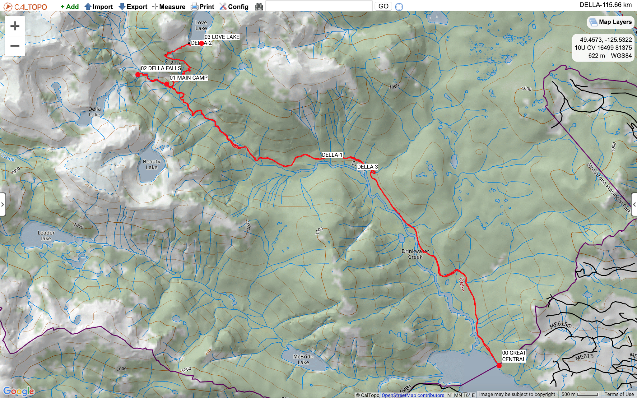
Route (Data logged with Suunto 9 Baro and Suunto App)
I joined a group of two other hikers on the Della Falls Water Taxi for a smooth 45 minute boat ride 35 km across Great Central Lake. Transport Canada requires all passengers of small vessels to wear face masks for boat rides longer than 30 minutes if 2 meter distancing cannot be maintained. Make sure that everyone in your group has a face covering of some kind. After unloading at the BC Parks dock, the trip began. The approach was in decent shape with recent windfall clearings, a little muddy near the swamps, and a bushy few kilometres before Margaret Creek. The Love Lake Trail was mostly clear except for a couple of easily passed blowdowns. The snow line started at 1260 m above the Della Falls lookout (GR 173818). Snow travel was mostly on hard consolidated snowpack except around the big boulders, rock walls, and the edge of Love Lake. A sudden posthole could surprise, injure, or cold soak the unsuspecting hiker. With careful consideration, it was possible to navigate to a dry picnic rock beside Love Lake and enjoy fine views towards Mount Septimus and Mount Rosseau. The return route back to camp is always easier for me than the way up. I enjoyed more spectacular views of Della Falls, Della Lake, Nine Peaks, and Big Interior. The hike out the next day was a bit slicker then the way in, but trending downslope made for an easier egress.
- Day 1, Della Falls Trailhead (94 m, GR 252738) to Della Falls Main Camp (560 m, GR 170811). Distance: 14.85 km, Duration: 4:57'28, Ascent 574 m, Ascent Time: 2:29’34, Descent: 115 m, Descent Time: 33’48.0.
- Day 2, Della Falls Main Camp (560 m, GR 170811) to Love Lake (1218 m, GR 180821). Distance: 8.31 km, Duration: 6:28'53, Ascent 788 m, Ascent Time: 2:02’16, Descent: 797 m, Descent Time: 1:59’22.
- Day 3, Della Falls Main Camp (560 m, GR 170811) to Della Falls Trailhead (94 m, GR 252738). Distance: 14.80 km, Duration: 5:04:30, Ascent: 118 m, Ascent Time: 20’36.0, Descent: 580 m, Descent Time: 2:15’24.
Wildlife
There was not much in the way of mega fauna on this high traffic route. Some black bear sign included a few piles of scat between 0 km and 4 km on the approach. Bird viewing included bald eagles, Copper’s hawks, woodpeckers (sapsuckers, maybe a downy), Pacific wrens, varied thrushes, hermit thrushes, and many robins. The most abundant wildlife besides the lush temperate rainforest flora was the heavy ambush of mosquitos between 0 km and 5 km. The attack was an intense feeding frenzy and some unprepared hikers were not too happy. Cover yourselves right up and bring bug spray and/or a head net.
Hazards
Besides the mosquitos, hazards included slippery roots and algae covered rocks in the creek crossings, slanted and slippery bridge decks, the cable car crossing and associated pinch points (GR 190794), a short but tricky boulder hop right along the edge of a rushing Drinkwater Creek (GR 181802), and the potential to posthole through the rapidly melting snowpack above 1260 m, around and maybe even into a partially frozen Love Lake (GR 180821).
Notes
The hike along Drinkwater Creek up to Della Falls is a Vancouver Island classic. A rich local history and the lure of seeing one of Canada’s highest waterfalls makes this a popular route for backpackers. However, maybe too many hikers and not enough rules has turned this zone into the wild west of Strathcona Park. Myself and two others dismantled at least three illegal fire pits around the Della Falls Main Camp, plus two up at the edge of Love Lake. From BC Parks: “Fires are not permitted anywhere or at any time (all seasons) within Strathcona Park, except in authorized and provided BC Parks steel fire rings. This regulation is in effect at all times of the year. No open fires are allowed in any backcountry areas.” Some campers thought it was okay to use the old historic mining artifacts to erect metal borders around their makeshift fire pits for the evening. The forest was damp on this trip, but in the dry season the upper Drinkwater Valley could set ablaze by drifting embers. Another concern was several dogs running free along the trail on my egress. From BC Parks: “Pets/domestic animals must be on a leash and under control at all times and are not allowed in beach areas or park buildings. You are responsible for their behaviour and must dispose of their excrement. Backcountry areas are not suitable for dogs or other pets due to wildlife issues and the potential for problems with bears.” One more concern was the lack of BC Parks camping infrastructure and the crowded sites. The Della Falls Trail is ready to be included in the Strathcona Park core area with better regulations, signage, tent pads, outhouses, more steel food lockers, permits, and a weekend patrol to enforce the rules. A park facility operator could station themselves at Della Falls on the busy summer weekends, check permits, educate campers, and take care of some trail maintenance along the way. This gem of a trip needs more attention from the land managers and deserves more respect from visiting hikers. All things considered, I enjoyed revisiting the Della Falls Trail for a fourth time, and look forward to returning later in the season. By then, the warmer weather and subalpine melt will increase the likelihood of taking a dip in Love Lake.
Mike Blake
ACMG HG
mbguiding.ca