Strathcona Provincial Park, Della Falls Trail - July 11-13, 2020
Vancouver Island, British Columbia, Canada

Jul 15, 2020
I returned from guiding our first group of clients of the season on the Della Falls Trail in Strathcona Park. Our primary objective was to hike to Della Falls Camp for two nights. A secondary objective was to complete the side trip to Love Lake and explore the subalpine basin below Mount Septimus and Mount Rosseau. The steep Love Lake Trail offers the best views of the falls. Our group did well following our new Operational Guidelines and Safety Plan for COVID-19. We practiced and demonstrated physical distancing, proper hygiene, and being more self-sufficient, all while enjoying a safe and fun trip. We got hammered by wet weather on the hike in, dried out at camp, had some challenging hiking days, and sun-bathed on the boat ride home. The land management issues and negative human impact on this zone of Strathcona Park remains an ongoing concern.
Weather (Data logged with Kestrel Weather and Environmental Meters Drop D3)
The forecast was for cool temperatures and a high probability of precipitation with a clearing and warming trend. As predicted, we started the trip off cool and wet on day one, dried out on day two, and enjoyed sunny conditions on day three.
- Day 1, 0900 h, Della Falls Trailhead, 94 m, overcast, light rain, temperature 13.1ºC, humidity 94.4%, wind calm. 1600 h, Della Falls Main Camp, 560 m, overcast, no precipitation, temperature 11.7ºC, humidity 100.0%, wind calm.
- Day 2, 0630 h, Della Falls Main Camp, 560 m, partially cloudy, no precipitation, temperature 7.7ºC, humidity 100.0%, wind calm. 1000 h, 1st Viewpoint, 974 m, cloudy, no precipitation, temperature 12.0°C, humidity 100.0%, wind calm. 1310 h, Love Lake, 1235 m, cloudy, no precipitation, temperature 10.7ºC, humidity 76.6%, wind calm.
- Day 3, 0600 h, Della Falls Main Camp, 560 m, few clouds, no precipitation, temperature 5.9ºC, humidity 100.0%, wind calm. 1230 h, Della Falls Cable Car, 388 m, few clouds, no precipitation, temperature 12.9ºC, humidity 67.7%, wind calm. 1620 h, Della Falls Trailhead, 94 m, partially cloudy, no precipitation, temperature 22.3ºC, humidity 64.5%, wind calm.
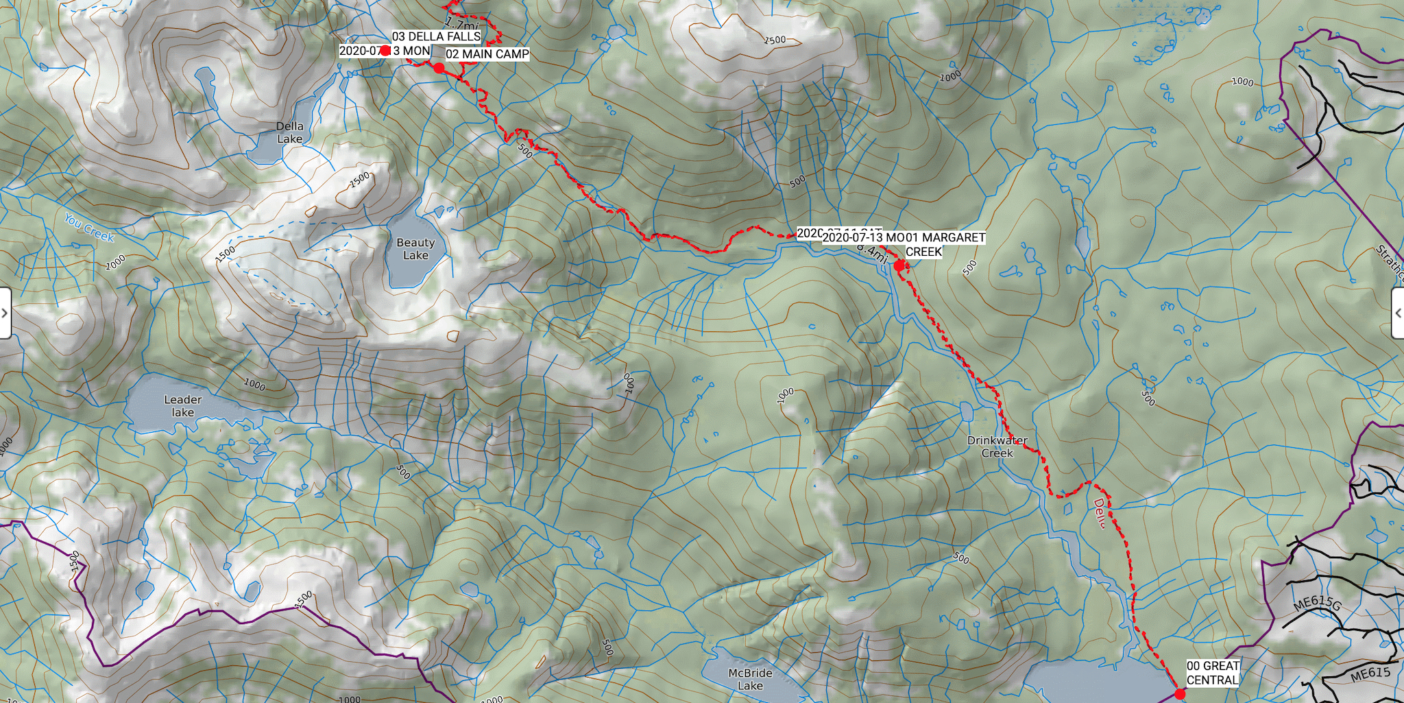
Route (Data logged with Suunto 9 Baro and Suunto App)
Captain Doug Moore ferried us up Great Central Lake on our own chartered Della Falls Water Taxi. Transport Canada requires all passengers of small vessels to wear face masks for boat rides longer than 30 minutes if 2 meter distancing cannot be maintained. Make sure that everyone in your group has a face covering of some kind. We unloaded at the BC Parks dock (94 m, GR 252738) and started the hike. The approach had been heavily travelled in the few weeks since my last trip and the path was muddy in places with all the precipitation. With a considerable amount of rain falling, all surfaces were slick. Be prepared for a good soaking if the overgrown bushy sections are still wet. The Love Lake Trail is mostly clear except for a couple of easily passed blowdowns. The snowpack above the main Della Falls Viewpoint (1190 m, GR 173818) has almost completely melted and the route is clearly visible on dirt and rock all the way to the shore of Love Lake (1235 m, GR 180821). We enjoyed spectacular views of Della Falls, Della Lake, and Love Lake. The summits of Nine Peaks, Big Interior, Septimus and Rosseau were obscured by lingering clouds. The sunny hike up to the Della Falls Base (635 m, GR 164813) and out on day three was a different experience, with dry trail and rock all the way back down to Great Central Lake. We even kicked up some dust.
- Day 1, Della Falls Trailhead (94 m, GR 252738) to Della Falls Main Camp (560 m, GR 170811). Distance: 14.85 km, Duration: 6:26’29, Ascent 577 m, Ascent Time: 2:54’31, Descent: 145 m, Descent Time: 39’00.0.
- Day 2, Della Falls Main Camp (560 m, GR 170811) to Love Lake (1235 m, GR 180821). Distance: 8.46 km, Duration: 7:29’02, Ascent 813 m, Ascent Time: 2:52’12, Descent: 827 m, Descent Time: 2:10’44.
- Day 3, Della Falls Main Camp (560 m, GR 170811) to Della Falls Base (635 m, GR 164813) return. Distance: 1.68 km, Duration: 58’57.7, Ascent: 63 m, Ascent Time: 19’39.0, Descent: 58 m, Descent Time: 17’21.0. Della Falls Main Camp (560 m, GR 170811) to Della Falls Trailhead (94 m, GR 252738). Distance: 14.75 km, Duration: 6:21’22, Ascent: 562 m, Ascent Time: 2:41’11, Descent: 562 m, Descent Time: 2:41’11.
Wildlife
No mega fauna viewing. However, we were treated to fresh elk tracks, including a set with big and little prints. I have never seen elk sign in the Drinkwater Valley before. This observation caused me concern because so many loose dogs are on the run. Other animal sign included squirrel middens with owners guarding their stashes, and one fresh pile of black bear scat on the way out. Birds included the usual gamut of Strathcona locals: hermit thrushes, varied thrushes, Pacific wren, a close encounter with a ruffed grouse, whiskey jacks, chickadees, and Swainson’s thrushes. The most abundant life viewed and identified on this trip included dozens of species of wildflowers including: red columbine, coral root, ghost pipe, gnome plant, twinflower, hellebore, lupines, tiger lily, arnica, wintergreen, valerian, single delight, queen’s cup, and many berries, ferns, mosses, and trees.
Hazards
Hazards included the relentless mosquito infestation that began in the Drinkwater estuary and continued for several kilometres up the valley floor. Do not stop moving here unless absolutely necessary. I had a bug net and really appreciated it. Slippery roots and algae covered rocks in the creek crossings, slanted and slick bridge decks, were all even more hazardous with the increasing rate of precipitation on the way in. The cable car crossing with associated pinch points is always a spot to take extra care. There are many high touch points and dozens of travelling hikers grabbing the cart and rope. Bring gloves and use hand sanitizer before and after.
Notes
With three weeks between trips on the Della Falls Trail, I had the opportunity to observe the same issues that make this area at risk for an accidental wildfire, contamination from human waste, and wildlife being disturbed by loose dogs. We witnessed several illegal campfires around the main campsites, and new campfire rings both down on the valley floor and up in the sensitive subalpine zone towards Love Lake. Human waste has increased around the campsites. The green throne is so smelly that many campers do their business in the bushes directly adjacent to it, leaving the area a biological hazard zone. There were a few dogs on leashes and under control, but several were running loose along the trail and around campsites. This ongoing loose dog issue certainly has an affect on the wildlife or lack there of it. We have contacted BC Parks to share our observations and are awaiting a response. We are hopeful for a future plan of attack to resolve some of these issues. The Della Falls Trail trip is an exceptional mountain backpacking experience and would be even better if it was respected more by its visitors.
Mike Blake
ACMG HG
mbguiding.ca