Strathcona Provincial Park, Bedwell Lakes Trail - June 26-28, 2020
Vancouver Island, British Columbia, Canada

Jun 30, 2020
I returned from my second three-day solo training and reconnaissance mission into the backcountry of Strathcona Park. The Bedwell Lakes Trail is another Vancouver Island classic. My objectives included: staging and car camping at Buttle Lake Campground, backcountry camping for two nights at Bedwell Lake, day hiking up to Little Jim Lake and Cream Lake, viewing Della Falls from a new lookout, and hiking out to spend a final night car camping at Ralph River Campground. The Bedwell Lakes Trail is one of the most popular trips in the Buttle Lake zone of Strathcona Park for many reasons: efficient access from the higher elevation trailhead, a well-engineered and graded approach to the subalpine, BC Parks Core Area infrastructure and premium tent pad camping, and mind-blowing vistas. On the hike in, I counted 16 vehicles at the trailhead. On the hike out…45. I did not see any litter or fires on this trip. Big thanks to 43K Wilderness Solutions for doing such a fine job managing this section of the park.
Weather (Data logged with Kestrel Weather and Environmental Meters Drop D3)
The forecast was for cloudy skies and cool temperatures with a clearing trend. The weather on day one included a super-saturated valley bottom fog layer. Anything not sealed would get wet. My tarp over camp collected water and dripped all night. On day two, the views opened up under broken clouds. By day three, the skies were clear and I enjoyed perfect weather.
- Day 1, 1100 h, Bedwell Lakes Trailhead, 555 m, obscured sky, light rain, temperature 13.3ºC, humidity 100.0%, wind calm. 1600 h, Bedwell Lake Camp, 935 m, obscured skies, light rain, temperature 10.2ºC, humidity 100.0%, wind light S.
- Day 2, 0600 h, Bedwell Lake Camp, 935 m, obscured sky, no precipitation, temperature 6.7ºC, humidity 100.0%, wind light SW. 1300 h, Della Falls Viewpoint, 1360 m, scattered clouds, no precipitation, temperature 14.0°C, humidity 57.8%, wind moderate NW. 1700 h, Bedwell Lake Camp, 935 m, broken clouds, no precipitation, temperature 13.1ºC, humidity 60.0%, wind light NW.
- Day 3, 0545 h, Bedwell Lake Camp, 935 m, clear sky, no precipitation, temperature 6.9ºC, humidity 84.0%, wind light NW. 1100 h, Bedwell Lakes Trailhead, 555 m, clear sky, no precipitation, temperature 11.0ºC, humidity 72.8%, wind calm.
Route (Data logged with Suunto 9 Baro and Suunto App)
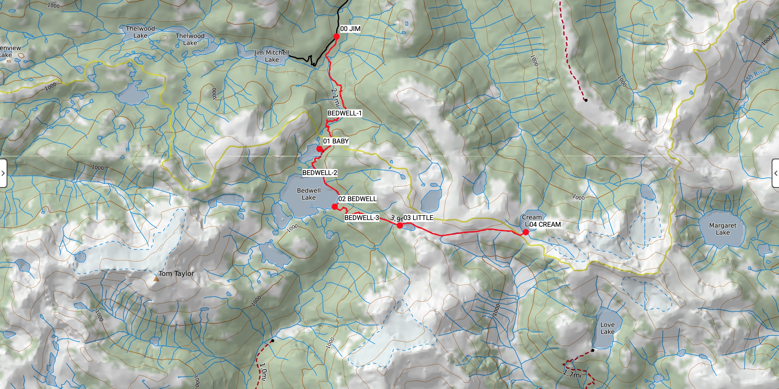
The Bedwell Lakes Trailhead (GR 127886) is 170 m south of the main parking pull off and signage on Jim Mitchell Lake Rd. The first 500 m of trail along the valley bottom is smooth and flat up to the suspension bridge and wooden bridge over Thelwood Creek (GR 125882). The trail quickly turns into a steep hillside with meandering and reinforced retaining walls and upward switchbacks. The trail was mostly clear, with a few snowy patches beginning at the top of the ridge (GR 125866) before Baby Bedwell Lake, and along the edge of Bedwell Lake (GR 124857). All of the creeks were easily forded. The many wood structures (bridges, boardwalks, ramps, and stairs) and the mangled mess of roots were very slippery. Mud was prevalent. The route from the Bedwell Lakes Trailhead to Bedwell Lake is easy to follow. Onwards from Bedwell Lake to Little Jim Lake and beyond to Cream Lake requires more savvy wilderness navigation skills. Snow patches were encountered above Bedwell Lake, with solid snow above Little Jim Lake (GR 139847) at 1230 m. There were many rock islands drying through the snowpack of three meters deep in places. It was dry on the ridge top at the Cream Lake Lookout (GR 162845) and Della Falls Viewpoint (GR 161845). Fine views opened up towards Flower Ridge and partially frozen Cream Lake. Mount Septimus remained obscured, while Nine Peaks and Big Interior were visible under broken clouds. The hike out was much drier with improved route conditions and less mud.
- Day 1, Bedwell Lakes Trailhead (555 m, GR 127886) to Bedwell Lake Camp (935 m, GR 126852). Distance: 6.54 km, Duration: 3:11’01, Ascent 549 m, Ascent Time: 1:52’40, Descent: 178 m, Descent Time: 43’33.0.
- Day 2, Bedwell Lake Camp (935 m, GR 126852) to Cream Lake Lookout (1340 m, GR 162845). Distance: 5.35 km, Duration: 3:05’35, Ascent 484 m, Ascent Time: 1:42’36, Descent: 84 m, Descent Time: 19’40.0. Cream Lake Lookout (1340 m, GR 162845) to Bedwell Lake Camp (935 m, GR 126852). Distance: 5.12 km, Duration: 2:21’39, Ascent 81 m, Ascent Time: 20’32.0, Descent: 489 m, Descent Time: 1:30’24.
- Day 3, Bedwell Lake Camp (935 m, GR 126852) to Bedwell Lakes Trailhead (555 m, GR 127886). Distance: 6.03 km, Duration: 2:52’37, Ascent: 176 m, Ascent Time: 39’45.0, Descent: 578 m, Descent Time: 1:36’46.
Wildlife
No mega fauna sign or viewings. Bird viewing included hummingbirds, varied thrushes, hermit thrushes, and whiskey jacks. Some ptarmigan sign in the snow above Little Jim Lake. Lots of slugs in the forest. The most interesting wildlife experience were the 100’s of frogs serenading from dusk to dawn in the ponds above Bedwell Lake. Two frogs in the pond next to my tent pad kept me awake all night with their croaking. Bring earplugs for the frogs.
Hazards
Hazards included very slippery wooden structures, roots, and rocks on the approach. Post-holing in the snow above and along the edge of Little Jim Lake. Some of the snow bridges above creek drainages looked like they were about to melt through soon. Pay attention to your map and terrain to avoid a sudden and potentially painful drop down into a creek bottom.
Notes
The Bedwell Lakes Trail is a very popular but spectacular trip into the heart of Strathcona Park. I was impressed with the amount of energy going into keeping this Core Area of Strathcona in tip-top shape even with the extra pressure of so many visitors. 43K Wilderness Solutions does a great job maintaining the trail network and camping infrastructure. I met Aiden, a 43K Park Facility Operator (PFO) who was friendly to chat with even after he had the not so fun job of cleaning the Bedwell Lake outhouse. I met another friendly and informative 43K PFO, James, who checked me into Ralph River Campground. These guys are doing an excellent job keeping the trails clear, checking permits, and educating visitors. I look forward to spending more time in this zone of the park later in the summer.
Mike Blake
ACMG HG
mbguiding.ca