Strathcona Provincial Park, Augerpoint Traverse - September 10-13, 2019
Vancouver Island, British Columbia, Canada

Sep 14, 2019
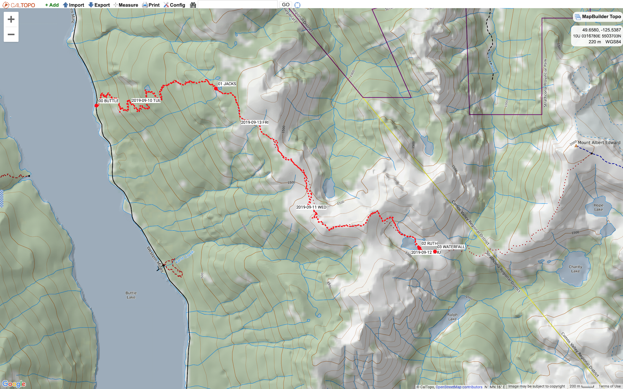
We just returned from guiding an attempt of the Augerpoint Traverse in Strathcona Provincial Park. Our original objective was to hike the route eastbound from Jack’s Trailhead to Paradise Meadows over four days. Due to unfavourable weather and poor route conditions, our actual trip was much different. We spent 41 hours pinned down at two adjacent camps near Ruth Masters Lake, waiting for conditions to improve. Rather than push into higher alpine terrain towards the northeast, we eventually retreated back northwest to our entry point.
Weather (Data logged with Kestrel Weather and Environmental Meters Drop D3)
- Day 1, 1000 h, Jack’s Trailhead, 235 m, broken sky, no precipitation, temperature 14.4ºC, humidity 85.9%, wind calm. 1930 h, Jack’s Tarn, 1415 m, broken sky, no precipitation, temperature 9.5ºC, humidity 82.5%, wind calm.
- Day 2, 0600 h, Jack’s Tarn, 1415 m, overcast sky, no precipitation, temperature 7.0°C, humidity 100.0%, calm. 1215 h, Augerpoint Col, 1633 m: overcast sky, light rain, temperature 7.2°C, humidity 98.4%, wind light SE. 1800 h, Ruth Masters Lake, 1440 m: obscured sky, light rain, temperature 7.6°C, humidity 100.0%, wind light SE.
- Day 3, 1200 h, Ruth Masters Waterfall, 1405 m: overcast sky, moderate rain, temperature 8.0°C, humidity 100.0%, wind moderate SE. 1800 h, Ruth Masters Waterfall, 1405 m broken sky, no precipitation, temperature 8.7°C, humidity 100.0%, wind light SW.
- Day 4, 1020 h, Ridge Top, 1710 m, obscured sky, no precipitation, temperature 6.2°C, humidity 100.0%, wind light NW. 1300 h, Jack’s Tarn, 1420 m, obscured sky, light rain, temperature 8.9°C, humidity 100.0%, wind light SE.
Route (Data logged with Suunto 9 Baro and Suunto App. Data imported and resampled in CalTopo)
- Day 1, Jack’s Trailhead (235 m, GR 165065) to Jack’s Tarn. Distance: 5.56 km, Duration: 5:50’46, Ascent 1149 m, Ascent Time: 3:48'53, Descent: 3 m, Descent Time: 0:41'0. CalTopo: 4.11 km, +1227/-49 m.
- Day 2, Jack’s Tarn to Ruth Masters Lake. Distance: 6.70 km, Duration: 4:53’53, Ascent 475 m, Ascent Time: 1:48'58, Descent: 450 m, Descent Time: 1:38'19. CalTopo: 5.88 km, +471/-452 m.
- Day 3, Ruth Masters Lake to Ruth Masters Waterfall. Distance: 0.69 km, Duration: 0:35’29, Ascent: 3 m, Ascent Time: 0:01’20, Descent: 35 m, Descent Time: 0:11’54. CalTopo: 0.33 km, +4/-27 m.
- Day 4, Ruth Masters Waterfall to Jack’s Trailhead. Distance: 12.13 km, Duration: 8:50’13, Ascent: 510 m, Ascent Time: 2:06’01, Descent: 1644 m, Descent Time: 4:29’26. CalTopo: 10.12 km, +471/-1641 m.
Wildlife
We viewed several groups of Vancouver Island white-tailed ptarmigan (Lagopus leucurus saxatilis) in summer plumage. With respect to other birds, we heard many chestnut-backed chickadees (Poecile rufescens). This small passerine bird is the only species of chickadee found on Vancouver Island. There were a few angry squirrels who chirped at us. We saw two large large piles of purple, blueberry-filled bear scat. The animals were smarter than us, staying at home and sheltered from the weather.
Hazards
Low visibility due to clouds and precipitation made for challenging navigation. Familiarity with the route and detailed maps were appreciated by the entire party. Periods of intense precipitation flooded parts of the route. Waterfalls appeared and disappeared during our trip. We opted to stay bunkered down in camp during those times. No rockfall was observed.
Notes
Our first camp at Ruth Masters Lake was by the outlet on a durable surface. Intense precipitation during our second night flooded the camp. Two Mountain Safety Research tents were compromised and required a thorough wiping with a pack towel and air drying under our group tarp to make them livable again. The Hyperlight Mountain Gear Dirigo 2 (waterproof Dyneema Composite Fabric) was the only tent of the three that held up. We moved camp 700 m east and 35 m down to the meadow by the waterfall for our third night. There was much better drainage and a bit more protection from the weather. We setup the compromised tents under the group tarp. On the descent back to the trailhead, an enthusiastic participant summarized our experience: “There’s only one season in the mountains. Be ready for all conditions.” All in all a good trip, with lots of experiential learning, and everyone safe with a smile on their face in the warm Ambassador Transportation shuttle home.
Mike Blake
ACMG HG
mbguiding.ca