Avalanche Forecast
Sea To Sky

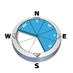
Wind slabs and cornices are the main concern for Wednesday. Forecast new snow and strong winds will likely add a storm slab problem by Thursday morning. Be alert to changing conditions and increased hazard.
Avalanche Problem 1: Wind Slabs
What Elevation?

Which Slopes?
Chances of Avalanches?

Expected Size?

Travel and Terrain Advice
- Use ridges or ribs to avoid pockets of wind loaded snow.
- Be cautious as you transition into wind affected terrain.
- Stay off recent wind loaded areas until the slope has had a chance to stabilize.
Avalanche Problem 2: Cornices
What Elevation?
Which Slopes?

Chances of Avalanches?
Expected Size?

Fragile looming cornices exist. They require respect and may surprise you with nasty consequences. Use extra caution around, on and below ridge crests.
Travel and Terrain Advice
- Give cornices a wide berth when travelling on or below ridges.
- Falling cornices may trigger large avalanches on the slopes below.
Avalanche Summary
On Monday, cornice control done with the use of explosives triggered numerous cornices up to size 2.5, mostly just entraining snow mass from the slope below. The larger cornice failure (2.5) did pull a small slab avalanche on the slope below. Cornices and wind slab avalanches remain touchy to rider triggers.
Snowpack Summary
We've had small amounts of new snow over the past several days. Winds, however, have been consistently strong from the south (east), forming reactive wind slabs in exposed downwind (lee) terrain. Snow surfaces vary with wind pressed, scoured or 10 cm of fresh, low density snow in the alpine. Treeline and below treeline a melt-freeze crust exists with moist snow below 1500 m.
The new snow adds to the 170 cm of snow that fell during the last few weeks of January. These series of storms were accompanied by strong to extreme winds which resulted in extensive scouring and impressive cornice growth in upper elevation terrain. These accumulations sit on a crust from mid-January which generally shows signs of bonding to the overlying snow; however, it has the potential to "wake-up" with a large trigger such as a cornice fall.
Below this, the snowpack is thought to be generally strong and well-settled.
Weather Forecast
Wednesday: 5-10 cm of new snow accompanied by strong southwest winds at ridgetop elevations. Freezing levels near 1500 m.
Thursday: Another 10-15 cm expected overnight and tapering off throughout the day. Ridgetop winds light with strong gusts from the southwest. Freezing levels near 1400 m.
Friday: A mix of sun and cloud as the arctic front shifts over the region. Alpine temperatures near -12 with a high of -4. Light-moderate ridgetop winds from the northeast and freezing levels near 900 m.
Avalanche Forecasts in your Inbox
Avalanche Canada has switched to an RSS feed for its daily forecasts. This is a much more flexible method that allows automatic delivery to your email inbox, or to an RSS reader of your choice.
What are RSS feeds?
RSS (Really Simple Syndication) is a popular standardized file format allowing up-to-date delivery of web-based content. RSS feeds enable you to receive content updates from websites, delivered to your email through an RSS aggregator (such as blogtrottr.com) or viewed through applications called RSS readers (such as feedly.com).
Set up an RSS feed for your email:
Select a RSS aggregator
- Sea To Sky URL:
http://www.avalanche.ca/api/forecasts/sea-to-sky.rss - Copy the url and paste it into the appropriate field of your RSS aggregator.
- Fill in your email address.
- Voila! Watch the Avalanche Canada forecast roll into your inbox.
Forecast Disclaimer
Avalanche Canada's Public Avalanche Bulletin, and other information and services provided by Avalanche Canada, are intended for personal and recreational purposes only.
**THIS INFORMATION IS PROVIDED "AS IS" AND IN NO EVENT SHALL THE PROVIDERS BE LIABLE FOR ANY DAMAGES, INCLUDING, WITHOUT LIMITATION, DAMAGES RESULTING FROM DISCOMFORT, INJURY, OR DEATH, CLAIMS BY THIRD PARTIES OR FOR OTHER SIMILAR COSTS, OR ANY SPECIAL, INCIDENTAL, OR CONSEQUENTIAL DAMAGES, ARISING OUT OF THE USE OF THE INFORMATION.**
The user acknowledges that it is impossible to accurately predict natural events such as avalanches in every instance, and uses the data in this bulletin with this always foremost in mind. The accuracy or reliability of the data is not guaranteed or warranted in any way and the Providers disclaim liability of any kind whatsoever, including, without limitation, liability for quality, performance, merchantability and fitness for a particular purpose arising out of the use, or inability to use the data.
Recent winds have created pockets of reactive soft slab below ridge crests and on immediate leeward features at higher elevations. New wind slabs may form with forecast snow amounts.