ACMG Mountain Conditions Summary for the Rockies and Columbia Mountains. June 12, 2020
WEATHER
After a week of great weather, the weather is forecast to start deteriorating this evening with a wet weekend to look forward to across western Canada. Freezing levels will drop a bit, from 3000 m currently to around 2000 m. This could provide up to 15 cm of fresh snow, way up high in the alpine.
EAST SLOPES CONDITIONS
Apart from this coming storm, the Eastern slopes of the Rockies are drying out nicely and many of the scrambles and ridge traverses are coming into shape. Expect some snow patches on high N aspects and check for ticks when you get home.
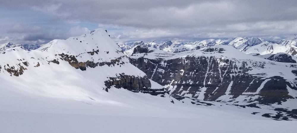
MAIN RANGES CONDITIONS
The snowline in the main ranges of the Rockies and Columbia Mountains is still hovering around treeline on North aspects with South aspects and exposed ridges drying out more rapidly. You can expect to encounter snow patches or snow covered trails on many shaded aspects above 1900 m with snow conditions varying from nice supportive snow, to deep postholing depending on the temperatures and snowpack depth. Popular scramble routes such as the SW Ridge of Mt Temple are still holding a lot of snow and need more time for avalanche hazards to settle out and to come into condition.
Snow travel conditions this weekend will depend on the overnight temperatures, cloud cover, freezing levels and rain/snow amounts.
GLACIER TRAVEL
The glaciers still have good snow coverage and travel on cool mornings has been decent in the last few days. Surface instabilities have generally settled out and bonded, or melted off with the heat.
HAZARDS
Concerns this week have been normal daytime heating hazards such as weakening crevasse bridges, wet snow avalanches, cornice failures and increased rockfall.
With the forecasted storm, concerns for new snow loading will return this weekend. This could include windslab and newly covered crevasses in the high alpine.
If venturing into higher alpine rock routes, keep a close eye on melting snow patches that might be spitting rocks your direction.
Thunderstorms are also a hazard to consider in the next few days.
RECENT ACTIVITY
Updated reports from the last week are as follows:
- a lot of ski mountaineering activity including alpine forays around Rogers Pass and Rockies classics such as Silverhorn and Skyladder.
- Mt Hector was climbed yesterday, with great coverage and no sagging crevasses reported, skied from above the waterfall to the summit block. Dry walking below this.
- Silverhorn was skied (yet again) yesterday and reported in good condition with just a few icy patches.
- Most eastern and lower elevation climbing areas are in good condition. Continued vigilance for loose rocks as a result of the freeze thaw cycles of the past winter is important!
- Expect snow patches and muddy trails on shaded aspects as you approach treeline in the Rockies and Columbia Mtns
- North Face of Athabasca - reasonable shape in general though not much ice through the crux, good glacier travel
- Castle Mountain - Expect snow on the backside, in sheltered pockets and on the normal descent. Good water available at the hut.
- Mt Tupper W Ridge, Little Sifton and MacDonald NW Ridge in Glacier Park - while ski travel in the alpine is good, technical routes have yet to come into condition and are holding snow still.
- No reports yet from the Bugaboos but likely a fair bit of snow in the area.
Regards,
Tom Wolfe
Mountain Guide, ACMG