Avalanche Forecast
Kananaskis Country, Alberta Parks

We've had enough snow recently to increase the coverage and avalanche hazard. How the wind distributes the snow is the big question. Watch closely for windloading as the winds increase.
Avalanche Problem 1: Wind Slabs
What Elevation?

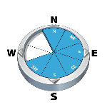
Which Slopes?
Chances of Avalanches?

Expected Size?

Travel and Terrain Advice
- Avoid freshly wind loaded features.
- Be careful with wind loaded pockets while approaching and climbing ice routes.
- Avoid lee and cross-loaded terrain near ridge crests.
Avalanche Summary
Nothing new today.
Snowpack Summary
10-20 cm of new snow came in yesterday and last night. While below treeline areas are improving for coverage, we are still below threshold in terms of avalanche problems. At treeline, the story changes significantly. We have two layers of interest: the "Halloween" crust and recent windslabs. The crust depth varies, but it is generally down 30-40cm from the top. The windslabs sit above the crust and vary in thickness (on average 20-40cm). Tests have had repeatable failures immediately below the crust on a layer facets. As of this afternoon, winds were increasing with windslab development ongoing.
Weather Forecast
We are expecting snow to come in for Sunday. In the meantime, westerly winds will increase to 55km tonight and tomorrow. Flurries will accompany winds, but amounts won't add up much until Sunday. Temperatures will remain steady at -10°.
Avalanche Forecasts in your Inbox
Avalanche Canada has switched to an RSS feed for its daily forecasts. This is a much more flexible method that allows automatic delivery to your email inbox, or to an RSS reader of your choice.
What are RSS feeds?
RSS (Really Simple Syndication) is a popular standardized file format allowing up-to-date delivery of web-based content. RSS feeds enable you to receive content updates from websites, delivered to your email through an RSS aggregator (such as blogtrottr.com) or viewed through applications called RSS readers (such as feedly.com).
Set up an RSS feed for your email:
Select a RSS aggregator
- Kananaskis Country, Alberta Parks URL:
http://www.avalanche.ca/api/forecasts/kananaskis.rss - Copy the url and paste it into the appropriate field of your RSS aggregator.
- Fill in your email address.
- Voila! Watch the Avalanche Canada forecast roll into your inbox.
Forecast Disclaimer
Avalanche Canada's Public Avalanche Bulletin, and other information and services provided by Avalanche Canada, are intended for personal and recreational purposes only.
**THIS INFORMATION IS PROVIDED "AS IS" AND IN NO EVENT SHALL THE PROVIDERS BE LIABLE FOR ANY DAMAGES, INCLUDING, WITHOUT LIMITATION, DAMAGES RESULTING FROM DISCOMFORT, INJURY, OR DEATH, CLAIMS BY THIRD PARTIES OR FOR OTHER SIMILAR COSTS, OR ANY SPECIAL, INCIDENTAL, OR CONSEQUENTIAL DAMAGES, ARISING OUT OF THE USE OF THE INFORMATION.**
The user acknowledges that it is impossible to accurately predict natural events such as avalanches in every instance, and uses the data in this bulletin with this always foremost in mind. The accuracy or reliability of the data is not guaranteed or warranted in any way and the Providers disclaim liability of any kind whatsoever, including, without limitation, liability for quality, performance, merchantability and fitness for a particular purpose arising out of the use, or inability to use the data.
The winds started to kick in this afternoon. Slabs will build quickly with the amount of available snow. Expect them to reach further down from ridge crests than we have been used to.