Avalanche Forecast
Lizard Range and Flathead

Freezing levels well above the mountain tops and sunny skies are intensely warming the snowpack, particularly around midday. Best to avoid areas with sun exposure, wind effect, and overhead avalanche terrain. Read our blog on the impact of warming.
Avalanche Problem 1: Loose Wet
What Elevation?

Which Slopes?

Chances of Avalanches?
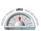
Expected Size?

Travel and Terrain Advice
- Start early to stay off south facing slopes during the heat of the day.
- Watch for signs that the snow is heating up such as pin-wheeling and point-releases below cliffs.
- Avoid terrain traps such as gullies and cliffs where small avalanches can have high consequence.
Avalanche Problem 2: Wind Slabs
What Elevation?

Which Slopes?
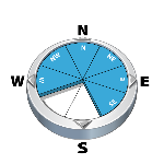
Chances of Avalanches?

Expected Size?
Wind slabs exist in the region and may still be reactive to human triggers. Use caution when entering into lee features.
Travel and Terrain Advice
- Approach lee and cross-loaded slopes with caution.
- Avoid steep, rocky, and wind effected areas where triggering slabs is more likely.
Avalanche Summary
Numerous storm and wind slabs to size 2 were reported in the region, being triggered naturally and by explosives. They were on all aspects, 30 to 50 cm deep, and most often at alpine elevations. Small loose avalanches were also noted on solar aspects.
The forecast warming and sunshine may wake up a deeper weak layer on steep south facing slopes resulting in large and destructive avalanches.
Snowpack Summary
20-30 cm of recent storm snow is settling rapidly with warm daytime temperatures. Expect moist snow on solar aspects and on all aspects up to 1400 m. This new snow is sitting on patchy surface hoar in parts of the region.
Cornices are large and prone to failure with warm air temperatures and sunny skies.
In the upper to mid snowpack, a surface hoar or facet layer buried mid-February is now 80 to 110 cm below the surface on sheltered northerly aspects.
Deeper in the snowpack, the widespread mid-December and late November weak layers are composed of a combination of crusts and sugary facets which are down 200-300 cm. These layers have been dormant but may be awoken by the warm and sunny weather throughout the weekend or by a large trigger, such as a falling cornice.
Weather Forecast
MONDAY: Sunny, light southwesterly winds, alpine temperature 1 C, freezing level 2300 m.
TUESDAY: Sunny, light southwesterly winds, alpine temperature 3 C, freezing level 2600 m.
WEDNESDAY: Mostly sunny, light southwesterly winds, alpine temperature 3 C, freezing level 2500 m.
Avalanche Forecasts in your Inbox
Avalanche Canada has switched to an RSS feed for its daily forecasts. This is a much more flexible method that allows automatic delivery to your email inbox, or to an RSS reader of your choice.
What are RSS feeds?
RSS (Really Simple Syndication) is a popular standardized file format allowing up-to-date delivery of web-based content. RSS feeds enable you to receive content updates from websites, delivered to your email through an RSS aggregator (such as blogtrottr.com) or viewed through applications called RSS readers (such as feedly.com).
Set up an RSS feed for your email:
Select a RSS aggregator
- Lizard Range and Flathead URL:
http://www.avalanche.ca/api/forecasts/lizard-range.rss - Copy the url and paste it into the appropriate field of your RSS aggregator.
- Fill in your email address.
- Voila! Watch the Avalanche Canada forecast roll into your inbox.
Forecast Disclaimer
Avalanche Canada's Public Avalanche Bulletin, and other information and services provided by Avalanche Canada, are intended for personal and recreational purposes only.
**THIS INFORMATION IS PROVIDED "AS IS" AND IN NO EVENT SHALL THE PROVIDERS BE LIABLE FOR ANY DAMAGES, INCLUDING, WITHOUT LIMITATION, DAMAGES RESULTING FROM DISCOMFORT, INJURY, OR DEATH, CLAIMS BY THIRD PARTIES OR FOR OTHER SIMILAR COSTS, OR ANY SPECIAL, INCIDENTAL, OR CONSEQUENTIAL DAMAGES, ARISING OUT OF THE USE OF THE INFORMATION.**
The user acknowledges that it is impossible to accurately predict natural events such as avalanches in every instance, and uses the data in this bulletin with this always foremost in mind. The accuracy or reliability of the data is not guaranteed or warranted in any way and the Providers disclaim liability of any kind whatsoever, including, without limitation, liability for quality, performance, merchantability and fitness for a particular purpose arising out of the use, or inability to use the data.
Rising freezing levels and sunny skies are causing intense warming of the snowpack on solar aspects. Peak danger will likely be during afternoon hours. Pay close attention to the effects of the sun on avalanche terrain and avoid overhead exposure.