Avalanche Forecast
Purcells

Fresh wind slabs and cornices have formed at higher elevations. Riding preserved powder in sheltered trees is a good option.
Avalanche Problem 1: Wind Slabs
What Elevation?

Which Slopes?

Chances of Avalanches?

Expected Size?

Travel and Terrain Advice
- Avoid travelling in areas that have been reverse loaded by winds.
- If triggered the wind slabs may step down to deeper layers resulting in large avalanches.
- Be cautious as you transition into wind affected terrain.
Avalanche Problem 2: Persistent Slabs
What Elevation?

Which Slopes?
Chances of Avalanches?

Expected Size?
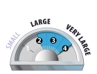
Several troublesome layers exist in the snowpack and may be reactive to large triggers such as a cornice or storm slab release. Human triggering may also be possible in shallow or thin, rocky areas.
Travel and Terrain Advice
- Avoid steep convexities or areas with a thin or variable snowpack.
- Pay attention to overhead hazards like cornices which could easily trigger persistent slabs.
- Avoid the runout zones of avalanche paths. Very large avalanches have been running full path.
Avalanche Summary
On Monday we received reports of a cornice triggered size 2.5 slab avalanche on a high north east alpine face near 2900m.
On Sunday, several natural wind slab avalanches to size 2 were reported on primarily east aspects between 2200m and 2600m.
On Sunday, skiers were able to intentionally trigger small (size 1) wind slab avalanches in immediate down wind (lee) features near ridge crests. See here for an update on conditions near Golden.
Although deeper, persistent avalanche activity is becoming less frequent, these avalanches point to the continued reactivity and destructive potential of these layers.
Snowpack Summary
Recent storm snow totals are 15-30 cm with more in the very south of the region near Kimberley, where totals are closer to 50 cm.
Moderate south west through north west winds shifted these accumulations into deeper, reactive slabs in wind-exposed terrain. The recent snow sits on a mix of older wind slabs in exposed higher elevation terrain, a sun crust on steep solar aspects and surface hoar on sheltered slopes.
Below the snow surface several persistent weak layers make up a troublesome snowpack which is not tolerating recent storm loads. In the top 1-2 m of the snowpack, two surface hoar/ crust layers buried in January can be found. Expect to find one or other of these on all aspects and elevations.
Deeper in the snowpack (around 200 cm deep) is a facet/crust/surface hoar layer from December, most prevalent at and below tree line.
Near the base of the snowpack is a crust/facet combo, most likely to be triggered from thin spots in the alpine.
All of these layers have produced large avalanches recently. The wide distribution and ongoing reactivity of these layers suggests that avoidance through choosing simple terrain is the best strategy.
Weather Forecast
Clear and cold for the foreseeable future, with overnight lows near -24 Celsius in some locations.
TUESDAY: Cloudy with sunny periods and isolated flurries. Tree line temperature around -14 Celsius. Light winds northerly 5-15 Km/hr.
WEDNESDAY: Cloudy with sunny periods and isolated flurries. Tree line temperatures around -14 Celsius. Winds moderate westerly 20-30 Km/hr.
THURSDAY: Sunny with cloudy periods. Tree line temperature around -12 Celsius. Winds light westerly.
Avalanche Forecasts in your Inbox
Avalanche Canada has switched to an RSS feed for its daily forecasts. This is a much more flexible method that allows automatic delivery to your email inbox, or to an RSS reader of your choice.
What are RSS feeds?
RSS (Really Simple Syndication) is a popular standardized file format allowing up-to-date delivery of web-based content. RSS feeds enable you to receive content updates from websites, delivered to your email through an RSS aggregator (such as blogtrottr.com) or viewed through applications called RSS readers (such as feedly.com).
Set up an RSS feed for your email:
Select a RSS aggregator
- Purcells URL:
http://www.avalanche.ca/api/forecasts/purcells.rss - Copy the url and paste it into the appropriate field of your RSS aggregator.
- Fill in your email address.
- Voila! Watch the Avalanche Canada forecast roll into your inbox.
Forecast Disclaimer
Avalanche Canada's Public Avalanche Bulletin, and other information and services provided by Avalanche Canada, are intended for personal and recreational purposes only.
**THIS INFORMATION IS PROVIDED "AS IS" AND IN NO EVENT SHALL THE PROVIDERS BE LIABLE FOR ANY DAMAGES, INCLUDING, WITHOUT LIMITATION, DAMAGES RESULTING FROM DISCOMFORT, INJURY, OR DEATH, CLAIMS BY THIRD PARTIES OR FOR OTHER SIMILAR COSTS, OR ANY SPECIAL, INCIDENTAL, OR CONSEQUENTIAL DAMAGES, ARISING OUT OF THE USE OF THE INFORMATION.**
The user acknowledges that it is impossible to accurately predict natural events such as avalanches in every instance, and uses the data in this bulletin with this always foremost in mind. The accuracy or reliability of the data is not guaranteed or warranted in any way and the Providers disclaim liability of any kind whatsoever, including, without limitation, liability for quality, performance, merchantability and fitness for a particular purpose arising out of the use, or inability to use the data.
Wind slabs remain reactive and could be slow to gain strength due to a mix of underlying weak surfaces. Watch for new wind slab development and reverse loading due to northwest through northeast winds.