Avalanche Forecast
Avalanche Bulletin - Jasper National Park

While we expect natural activity to drop off as recent storm and wind slabs settle out and the cold air takes over, the persistent slab problems still linger. Another storm in the forecast for Wednesday will provide a further test to the snowpack.
Avalanche Problem 1: Persistent Slabs
What Elevation?

Which Slopes?
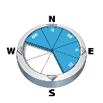
Chances of Avalanches?

Expected Size?

Travel and Terrain Advice
- If triggered the storm slabs may step down to deeper layers resulting in large avalanches.
Avalanche Problem 2: Wind Slabs
What Elevation?
Which Slopes?

Chances of Avalanches?

Expected Size?

Snow that began to accumulate last Sunday quickly settled into a touchy soft slab in many locations. In exposed areas, strong SW winds further developed these slabs midweek. 10-15cm of new snow that arrived Saturday and Sunday now hides these slabs.
Travel and Terrain Advice
- If triggered the storm/wind slabs may step down to deeper layers resulting in large avalanches.
- Be cautious as you transition into wind affected terrain.
Avalanche Problem 3: Loose Dry
What Elevation?

Which Slopes?
Chances of Avalanches?

Expected Size?

The new snow that fell Saturday and Sunday has triggered a few slabs as it has sluffed off of rock faces or steep terrain. Consider the potential for this if you enter steep or confined terrain.
Travel and Terrain Advice
- Avoid terrain traps, such as gullies, where the consequences of a small avalanche could be serious.
Avalanche Summary
Avalanche control on Wednesday along the Icefields Parkway produced numerous size 3 avalanches in the alpine, and many size 2-2.5 storm slab and loose avalanches at all elevations. Persistent slab avalanches were produced in the alpine where wind loaded areas provided enough of a load to trigger a step down to these mid-pack layers.
Snowpack Summary
10-15 cm of new snow arrived with a Northerly flow Saturday. This sits over recent wind and storm slabs formed by 40cm of snow pushed around mainly by strong SW winds. Midpack persistent weak layers, mainly preserved Jan 7surface hoar down 40 to 60cm and the rotten Dec 15 FC sitting just below are still a concern but remain stubborn to triggering.
Weather Forecast
Warm, wet, pacific air is over-riding the cold arctic air that arrived to Jasper with a NorthWesterly flow Feb 3. A few cm of snow can be expected overnight Sunday before the cold air wins out again yielding a return to clear, mainly calm and cold through Tuesday. Forecasts call for this same pattern to bring another push of Pacific air Wednesday
Avalanche Forecasts in your Inbox
Avalanche Canada has switched to an RSS feed for its daily forecasts. This is a much more flexible method that allows automatic delivery to your email inbox, or to an RSS reader of your choice.
What are RSS feeds?
RSS (Really Simple Syndication) is a popular standardized file format allowing up-to-date delivery of web-based content. RSS feeds enable you to receive content updates from websites, delivered to your email through an RSS aggregator (such as blogtrottr.com) or viewed through applications called RSS readers (such as feedly.com).
Set up an RSS feed for your email:
Select a RSS aggregator
- Avalanche Bulletin - Jasper National Park URL:
http://www.avalanche.ca/api/forecasts/jasper.rss - Copy the url and paste it into the appropriate field of your RSS aggregator.
- Fill in your email address.
- Voila! Watch the Avalanche Canada forecast roll into your inbox.
Forecast Disclaimer
Avalanche Canada's Public Avalanche Bulletin, and other information and services provided by Avalanche Canada, are intended for personal and recreational purposes only.
**THIS INFORMATION IS PROVIDED "AS IS" AND IN NO EVENT SHALL THE PROVIDERS BE LIABLE FOR ANY DAMAGES, INCLUDING, WITHOUT LIMITATION, DAMAGES RESULTING FROM DISCOMFORT, INJURY, OR DEATH, CLAIMS BY THIRD PARTIES OR FOR OTHER SIMILAR COSTS, OR ANY SPECIAL, INCIDENTAL, OR CONSEQUENTIAL DAMAGES, ARISING OUT OF THE USE OF THE INFORMATION.**
The user acknowledges that it is impossible to accurately predict natural events such as avalanches in every instance, and uses the data in this bulletin with this always foremost in mind. The accuracy or reliability of the data is not guaranteed or warranted in any way and the Providers disclaim liability of any kind whatsoever, including, without limitation, liability for quality, performance, merchantability and fitness for a particular purpose arising out of the use, or inability to use the data.
Control work on Wednesday produced several results on this layer, particularly in the alpine where storm slabs were able to entrain enough mass to step down to mid-pack instabilities. Field teams observed Whumpfing and moderate test results Sunday.