Avalanche Forecast
Avalanche Bulletin - Glacier National Park

Allow the snowpack time to adjust to the recent snow load. Avoid overhead hazard or spending anytime in runout zones as large avalanches have been running into valley bottoms.
Avalanche Problem 1: Storm Slabs
What Elevation?

Which Slopes?

Chances of Avalanches?

Expected Size?
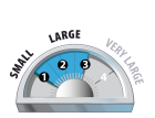
Travel and Terrain Advice
- Be careful with wind loaded pockets, especially near ridge crests and roll-overs.
- If triggered the storm slabs may step down to deeper layers resulting in large avalanches.
Avalanche Problem 2: Persistent Slabs
What Elevation?
Which Slopes?
Chances of Avalanches?

Expected Size?
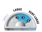
Natural avalanche activity on the persistent weak layers has tapered off recently. The Jan 16th, 4th and Dec 15th surface hoar layers are buried deep, but avalanches in the storm snow can step down and trigger these weak interfaces.
Travel and Terrain Advice
- Pay attention to overhead hazards like cornices which could easily trigger the deep persistent slab.
- Minimize overhead exposure; avalanches may reach the end of run out zones.
Avalanche Summary
Several avalanches reported yesterday from backcountry users, some of which buried regular skin track routes. Heavy snowfall and winds produced natural avalanches to size 3.0.
Artillery avalanche control produced numerous avalanches, size 2.0-3.5, with several avalanches dusting the highway.
Snowpack Summary
25cm in 24hrs brings the weekly snowfall total to ~150cm creating a healthy sized storm slab. Previous moderate to strong south winds have created pockets of windslab in the alpine. A meter and a half of settling snow sits over the Jan 16th surface hoar layer, which is the uppermost PWL and is still distinct and easy to pick out on pit walls.
Weather Forecast
Winter is great, especially when it snows a lot! Today we can expect to see another 5-10cm of it, giving us poor visibility in the alpine. Temps will range from -5 to -10 with 20km/hr ridgetop winds from the southwest. The next weather system will arrive Tuesday evening and continue into Thursday with forecasted snowfall amounts over 50cm.
Avalanche Forecasts in your Inbox
Avalanche Canada has switched to an RSS feed for its daily forecasts. This is a much more flexible method that allows automatic delivery to your email inbox, or to an RSS reader of your choice.
What are RSS feeds?
RSS (Really Simple Syndication) is a popular standardized file format allowing up-to-date delivery of web-based content. RSS feeds enable you to receive content updates from websites, delivered to your email through an RSS aggregator (such as blogtrottr.com) or viewed through applications called RSS readers (such as feedly.com).
Set up an RSS feed for your email:
Select a RSS aggregator
- Avalanche Bulletin - Glacier National Park URL:
http://www.avalanche.ca/api/forecasts/glacier.rss - Copy the url and paste it into the appropriate field of your RSS aggregator.
- Fill in your email address.
- Voila! Watch the Avalanche Canada forecast roll into your inbox.
Forecast Disclaimer
Avalanche Canada's Public Avalanche Bulletin, and other information and services provided by Avalanche Canada, are intended for personal and recreational purposes only.
**THIS INFORMATION IS PROVIDED "AS IS" AND IN NO EVENT SHALL THE PROVIDERS BE LIABLE FOR ANY DAMAGES, INCLUDING, WITHOUT LIMITATION, DAMAGES RESULTING FROM DISCOMFORT, INJURY, OR DEATH, CLAIMS BY THIRD PARTIES OR FOR OTHER SIMILAR COSTS, OR ANY SPECIAL, INCIDENTAL, OR CONSEQUENTIAL DAMAGES, ARISING OUT OF THE USE OF THE INFORMATION.**
The user acknowledges that it is impossible to accurately predict natural events such as avalanches in every instance, and uses the data in this bulletin with this always foremost in mind. The accuracy or reliability of the data is not guaranteed or warranted in any way and the Providers disclaim liability of any kind whatsoever, including, without limitation, liability for quality, performance, merchantability and fitness for a particular purpose arising out of the use, or inability to use the data.
Consistent snowfall has created a storm slab. Previous strong South winds have redistributed the new snow into a windslab in the Alpine and at Treeline. If triggered, the slab could step down to deeper persistent weak layers.