Avalanche Forecast
Avalanche Bulletin - Little Yoho

An intense storm overnight has tipped the scales and overloaded the weak layers in Little Yoho. A natural avalanche cycle to size 3 occurred Thursday. This will ease with minimal precip Friday and Sat, but will pick up again with a big storm Sunday
Avalanche Problem 1: Wind Slabs
What Elevation?

Which Slopes?

Chances of Avalanches?

Expected Size?

Travel and Terrain Advice
- Avoid all avalanche terrain.
- Avoid exposure to overhead avalanche terrain, large avalanches may reach the end of run out zones.
Avalanche Problem 2: Persistent Slabs
What Elevation?

Which Slopes?

Chances of Avalanches?

Expected Size?
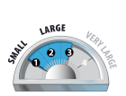
There are 3 weak layers in the upper snowpack: Jan 16, Jan 6, and Dec. 15. All are a mix of sun crust, surface hoar and facets depending on your aspect and elevation. Recent loading has overloaded these layers and we are seeing avalanche running far.
Travel and Terrain Advice
- Avoid all avalanche terrain.
- It is a good time to stay within the boundaries of a ski resort.
Avalanche Summary
Last nights snow triggered a natural avalanche cycle in Little Yoho on Thursday. Avalanches up to size 3 ran on Mt Dennis including the ice climbs Carlsberg Column, Extra Lite, Super Bok and Heineken Hall. A close call with a group of climbers who were leading the crux pitch of Carlsberg when an avalanche poured over there heads.
Snowpack Summary
20 cm of new snow overnight makes 70 cm of storm snow over the last 9 days. Alpine winds have distributed this into leeward areas but only at the highest elevations. Three persistent weak layers lurk in the upper half of the snowpack: Jan 16 down 40cm; Jan 6 down 55cm; Dec15 down 70 cm giving easy-mod test results
Weather Forecast
The SW flow continues, and we will see continued light snowfall amounts friday and saturday with a bigger looking storm coming in on Sunday. Approximately 3-5 cms per day with a drop in temperatures and winds. Sundays storm will be the one to watch and will likely trigger another avalanche cycle if it materializes.
Avalanche Forecasts in your Inbox
Avalanche Canada has switched to an RSS feed for its daily forecasts. This is a much more flexible method that allows automatic delivery to your email inbox, or to an RSS reader of your choice.
What are RSS feeds?
RSS (Really Simple Syndication) is a popular standardized file format allowing up-to-date delivery of web-based content. RSS feeds enable you to receive content updates from websites, delivered to your email through an RSS aggregator (such as blogtrottr.com) or viewed through applications called RSS readers (such as feedly.com).
Set up an RSS feed for your email:
Select a RSS aggregator
- Avalanche Bulletin - Little Yoho URL:
http://www.avalanche.ca/api/forecasts/little-yoho.rss - Copy the url and paste it into the appropriate field of your RSS aggregator.
- Fill in your email address.
- Voila! Watch the Avalanche Canada forecast roll into your inbox.
Forecast Disclaimer
Avalanche Canada's Public Avalanche Bulletin, and other information and services provided by Avalanche Canada, are intended for personal and recreational purposes only.
**THIS INFORMATION IS PROVIDED "AS IS" AND IN NO EVENT SHALL THE PROVIDERS BE LIABLE FOR ANY DAMAGES, INCLUDING, WITHOUT LIMITATION, DAMAGES RESULTING FROM DISCOMFORT, INJURY, OR DEATH, CLAIMS BY THIRD PARTIES OR FOR OTHER SIMILAR COSTS, OR ANY SPECIAL, INCIDENTAL, OR CONSEQUENTIAL DAMAGES, ARISING OUT OF THE USE OF THE INFORMATION.**
The user acknowledges that it is impossible to accurately predict natural events such as avalanches in every instance, and uses the data in this bulletin with this always foremost in mind. The accuracy or reliability of the data is not guaranteed or warranted in any way and the Providers disclaim liability of any kind whatsoever, including, without limitation, liability for quality, performance, merchantability and fitness for a particular purpose arising out of the use, or inability to use the data.
20 cm of new snow overnight and strong winds triggered a natural avalanche cycle today. Many avalanches failed as windslabs and stepped down to the deeper persistent weak layers.