Avalanche Forecast
Kootenay Boundary

It's getting trickier, the new snow and wind Thursday night should continue to form easily avoidable storm slabs, but we're not sure if this will worsen the persistent slab problem. Best to continue to stay conservative with terrain selection Friday.
Avalanche Problem 1: Storm Slabs
What Elevation?

Which Slopes?

Chances of Avalanches?

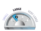
Expected Size?

Travel and Terrain Advice
- Be cautious as you transition into wind affected terrain.
- The recent snow may now be hiding windslabs that were easily visible before the snow fell.
- Be careful with wind loaded pockets, especially near ridge crests and roll-overs.
Avalanche Problem 2: Persistent Slabs
What Elevation?

Which Slopes?
Chances of Avalanches?

Expected Size?
A well-developed layer of surface hoar is buried up to 75 cm below the surface. Use extra caution in sheltered areas at and below treeline, especially if the overlying slab is thick and cohesive.
Travel and Terrain Advice
- Use conservative route selection, choose moderate angled and supported terrain with low consequence.
- Avoid open slopes and convex rolls at and below treeline where buried surface hoar may be preserved.
Avalanche Summary
On Wednesday reported avalanche activity was limited to sluffing from steep terrain. On Tuesday, a skier triggered a size 1.5 wind slab on a north-facing alpine slope in Kokanee Glacier Provincial Park. The skier went for a short ride, but was uninjured in the event. No other recent avalanches have been reported. As new snow accumulates over the next few days, fresh wind slabs should remain on your radar. More importantly, the December 15th interface will become deeper. With that, the overlying slab may settle and gain cohesion increasing the likelihood of triggering of this buried persistent weak layer.
Snowpack Summary
As of Thursday afternoon the storm has produced 10 to 20 cm of low density snow which has been accompanied by light to moderate wind out of south, southwest and even a bit of of southeast. The new snow overlies recently buried surface hoar, although at this point not much is known about the size or distribution of this potential weak layer.
Between 30 and 85 cm below the surface you'll find the December 15th interface which consists of a melt-freeze crust on steep, solar, higher elevation slopes and well-developed surface hoar which seems most pronounced in sheltered treeline terrain and below. The bond at this variable interface is of critical importance, especially in areas where the overlying slab is deep and well-consolidated.
The late November crust is now buried 60-100 cm and has been producing hard, resistant results in recent snowpack tests. Beneath this crust the lower snowpack is strong and well-settled.
Weather Forecast
Most of BC finds itself under the influence of a massive arctic high pressure system that has enveloped much of the province (and western Canada) in an unseasonably cold, dry arctic air mass. In contrast, a milder, moisture laden stream of air has taken aim at southwestern BC. These two air masses are set to clash over southern BC through Friday night producing a cold snowy pattern for the southern interior.
THURSDAY NIGHT: Freezing level at valley bottom, strong to extreme west/northwest wind at ridgetop. 5 to 20 cm of snow possible.
FRIDAY: Overcast, freezing level at valley bottom, strong northwest wind, trace of snow possible.
FRIDAY NIGHT: Freezing level at valley bottom, 5 to 20 cm of snow possible.
SATURDAY: Skies clearing throughout the day, freezing level at valley bottom, moderate northwest wind, 1 to 10 cm of snow possible.
SUNDAY: Clear skies, freezing level at valley bottom, light variable wind, no snow expected.
Avalanche Forecasts in your Inbox
Avalanche Canada has switched to an RSS feed for its daily forecasts. This is a much more flexible method that allows automatic delivery to your email inbox, or to an RSS reader of your choice.
What are RSS feeds?
RSS (Really Simple Syndication) is a popular standardized file format allowing up-to-date delivery of web-based content. RSS feeds enable you to receive content updates from websites, delivered to your email through an RSS aggregator (such as blogtrottr.com) or viewed through applications called RSS readers (such as feedly.com).
Set up an RSS feed for your email:
Select a RSS aggregator
- Kootenay Boundary URL:
http://www.avalanche.ca/api/forecasts/kootenay-boundary.rss - Copy the url and paste it into the appropriate field of your RSS aggregator.
- Fill in your email address.
- Voila! Watch the Avalanche Canada forecast roll into your inbox.
Forecast Disclaimer
Avalanche Canada's Public Avalanche Bulletin, and other information and services provided by Avalanche Canada, are intended for personal and recreational purposes only.
**THIS INFORMATION IS PROVIDED "AS IS" AND IN NO EVENT SHALL THE PROVIDERS BE LIABLE FOR ANY DAMAGES, INCLUDING, WITHOUT LIMITATION, DAMAGES RESULTING FROM DISCOMFORT, INJURY, OR DEATH, CLAIMS BY THIRD PARTIES OR FOR OTHER SIMILAR COSTS, OR ANY SPECIAL, INCIDENTAL, OR CONSEQUENTIAL DAMAGES, ARISING OUT OF THE USE OF THE INFORMATION.**
The user acknowledges that it is impossible to accurately predict natural events such as avalanches in every instance, and uses the data in this bulletin with this always foremost in mind. The accuracy or reliability of the data is not guaranteed or warranted in any way and the Providers disclaim liability of any kind whatsoever, including, without limitation, liability for quality, performance, merchantability and fitness for a particular purpose arising out of the use, or inability to use the data.
Continued snowfall and strong winds Thursday night and early Friday morning will likely continue to form storm slabs that will be most problematic in wind exposed terrain. If the snow feels hollow or stiff, wind slabs may be larger than expected.