Avalanche Forecast
Kananaskis Country, Alberta Parks

We are facing another warm spell tomorrow through Saturday. Snow stability is directly related to temperature. The danger ratings may change drastically and with little notice if the forecast holds true.
Avalanche Problem 1: Persistent Slabs
What Elevation?

Which Slopes?

Chances of Avalanches?

Expected Size?

Travel and Terrain Advice
- Be cautious in shallow snowpack areas where triggering is more likely.
- Avoid areas with overhead hazard.
- Extra caution needed around cornices with current conditions.
Avalanche Problem 2: Wind Slabs
What Elevation?

Which Slopes?
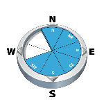
Chances of Avalanches?

Expected Size?

If/when the temperatures rise, expect the windslabs to become touchier.
Travel and Terrain Advice
- Avoid lee and cross-loaded terrain near ridge crests.
- Watch for clues, like sluffing off of cliffs, that the snowpack is warming up.
Avalanche Problem 3: Loose Wet
What Elevation?

Which Slopes?

Chances of Avalanches?
Expected Size?
It is hard to say if this will be an actual problem. But it is easy to say it is should be on your radar. Steep south aspects would be the likely place to encounter them.
Travel and Terrain Advice
- Watch for clues, like sluffing off of cliffs, that the snowpack is warming up.
Avalanche Summary
Nothing new today, but observations were limited.
Snowpack Summary
Overnight alpine winds have continued to reverse load south aspects and strip the northwest sides. Windslabs are now on most aspects and extending below ridgelines. They are also found near the bottoms of large alpine cliffs. Treeline has seen little change as temperatures and winds have remained steady. At both elevations, the crusts are the main concern. However, limited avalanche activity suggests the crusts are still intact and generally well bonded.
Weather Forecast
The big story is the warm weather coming our way. Starting tonight, we are expecting freezing levels to steadily rise. By midday tomorrow the freezing level is expected to reach 2900m. We are also going to see clear skies for the day. Expect some solar input to influence the snowpack. The winds will range from 20-40km/hr at ridge top. The temperatures will remain warm throughout thursday night.
Avalanche Forecasts in your Inbox
Avalanche Canada has switched to an RSS feed for its daily forecasts. This is a much more flexible method that allows automatic delivery to your email inbox, or to an RSS reader of your choice.
What are RSS feeds?
RSS (Really Simple Syndication) is a popular standardized file format allowing up-to-date delivery of web-based content. RSS feeds enable you to receive content updates from websites, delivered to your email through an RSS aggregator (such as blogtrottr.com) or viewed through applications called RSS readers (such as feedly.com).
Set up an RSS feed for your email:
Select a RSS aggregator
- Kananaskis Country, Alberta Parks URL:
http://www.avalanche.ca/api/forecasts/kananaskis.rss - Copy the url and paste it into the appropriate field of your RSS aggregator.
- Fill in your email address.
- Voila! Watch the Avalanche Canada forecast roll into your inbox.
Forecast Disclaimer
Avalanche Canada's Public Avalanche Bulletin, and other information and services provided by Avalanche Canada, are intended for personal and recreational purposes only.
**THIS INFORMATION IS PROVIDED "AS IS" AND IN NO EVENT SHALL THE PROVIDERS BE LIABLE FOR ANY DAMAGES, INCLUDING, WITHOUT LIMITATION, DAMAGES RESULTING FROM DISCOMFORT, INJURY, OR DEATH, CLAIMS BY THIRD PARTIES OR FOR OTHER SIMILAR COSTS, OR ANY SPECIAL, INCIDENTAL, OR CONSEQUENTIAL DAMAGES, ARISING OUT OF THE USE OF THE INFORMATION.**
The user acknowledges that it is impossible to accurately predict natural events such as avalanches in every instance, and uses the data in this bulletin with this always foremost in mind. The accuracy or reliability of the data is not guaranteed or warranted in any way and the Providers disclaim liability of any kind whatsoever, including, without limitation, liability for quality, performance, merchantability and fitness for a particular purpose arising out of the use, or inability to use the data.
Depending on when the warm air arrives, this layer may "wake up" as the surface slabs absorb the heat and weaken. South aspects will be more prone to localized weakening. Pay attention to temps and expect rapidly changing conditions.