Avalanche Forecast
Kananaskis Country, Alberta Parks

Our snowpack seems to get more and more complex as each day passes. Its a good idea to dig and familiarize yourself with conditions before venturing into avalanche terrain.
Avalanche Problem 1: Wind Slabs
What Elevation?

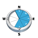
Which Slopes?
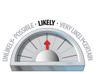
Chances of Avalanches?
Expected Size?

Travel and Terrain Advice
- Use caution in lee areas. Recent wind loading has created wind slabs.
- Avoid freshly wind loaded features.
- Watch for areas of hard wind slab in steep alpine features.
Avalanche Problem 2: Persistent Slabs
What Elevation?
Which Slopes?

Chances of Avalanches?

Expected Size?

The new crusts are preventing the deeper layers from disturbance. Remember, in shallow areas it is still possible to trigger the deeper layers.
Travel and Terrain Advice
- Be aware of the potential for wide propagations.
- Be cautious in shallow snowpack areas where triggering is more likely.
Avalanche Summary
Nothing new today.
Snowpack Summary
Snow profiles in the Highwood area today offered a good glimpse of our current snowpack. At treeline, snow depth is anywhere from 60-100cm deep. The surface snow character is dependant on wind exposure. Some areas are a softer slab, while others are quite hard (kicking to get a ski edge in) and often hollow sounding. The recent rain crusts (Nov 26 & Nov 23) are down 40cm on average and are 2 distinct layers. These 2 crusts are very obvious and well bonded for the time being. We'll have our hands full when that changes...The Oct 31crust is breaking down and variable in its character. Some places it is intact and others it has broken down/compressed and become part of the "base" snowpack. In both instances, it is still considered a weak layer and failing in tests after moderate loads. In the alpine it is very similar, but the depths are proportionally deeper. The surface wind slabs are concerning as they are failing under lighter loads (CT easy SC). Windloading in ongoing, so expect these numbers to change rapidly if the wind continues.
Weather Forecast
Winds will continue overnight and tomorrow. They will be westerly and about 65km/hr at ridge top. Only a few flurries are expected with no real accumulation. Temperatures will hover around -12 degrees.
Avalanche Forecasts in your Inbox
Avalanche Canada has switched to an RSS feed for its daily forecasts. This is a much more flexible method that allows automatic delivery to your email inbox, or to an RSS reader of your choice.
What are RSS feeds?
RSS (Really Simple Syndication) is a popular standardized file format allowing up-to-date delivery of web-based content. RSS feeds enable you to receive content updates from websites, delivered to your email through an RSS aggregator (such as blogtrottr.com) or viewed through applications called RSS readers (such as feedly.com).
Set up an RSS feed for your email:
Select a RSS aggregator
- Kananaskis Country, Alberta Parks URL:
http://www.avalanche.ca/api/forecasts/kananaskis.rss - Copy the url and paste it into the appropriate field of your RSS aggregator.
- Fill in your email address.
- Voila! Watch the Avalanche Canada forecast roll into your inbox.
Forecast Disclaimer
Avalanche Canada's Public Avalanche Bulletin, and other information and services provided by Avalanche Canada, are intended for personal and recreational purposes only.
**THIS INFORMATION IS PROVIDED "AS IS" AND IN NO EVENT SHALL THE PROVIDERS BE LIABLE FOR ANY DAMAGES, INCLUDING, WITHOUT LIMITATION, DAMAGES RESULTING FROM DISCOMFORT, INJURY, OR DEATH, CLAIMS BY THIRD PARTIES OR FOR OTHER SIMILAR COSTS, OR ANY SPECIAL, INCIDENTAL, OR CONSEQUENTIAL DAMAGES, ARISING OUT OF THE USE OF THE INFORMATION.**
The user acknowledges that it is impossible to accurately predict natural events such as avalanches in every instance, and uses the data in this bulletin with this always foremost in mind. The accuracy or reliability of the data is not guaranteed or warranted in any way and the Providers disclaim liability of any kind whatsoever, including, without limitation, liability for quality, performance, merchantability and fitness for a particular purpose arising out of the use, or inability to use the data.
Expect windslab development in lee and cross loaded gullies.