Avalanche Forecast
Avalanche Bulletin - Glacier National Park

Strong winds in the alpine have created a touchy windslab. The rainsoaked snowpack below treeline needs cold temps to regain strength.
Avalanche Problem 1: Wind Slabs
What Elevation?

Which Slopes?

Chances of Avalanches?

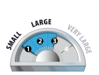
Expected Size?
Travel and Terrain Advice
- Use caution in lee areas. Recent wind loading have created wind slabs.
- Watch for whumpfing, hollow sounds, and shooting cracks.
Avalanche Problem 2: Wet Slabs
What Elevation?

Which Slopes?
Chances of Avalanches?

Expected Size?

Warm temperatures and rain yesterday have added moisture to an already saturated snowpack below treeline. Cooling temps overnight have created a very thin surface crust but if this crust breaks down there will be very little cohesion in the snowpack
Travel and Terrain Advice
- Avoid steep, open slopes.
- Use extra caution on slopes if the snow is moist or wet.
Avalanche Summary
In the Connaught creek drainage, skiers reported two natural size 2 wet slabs off of Mt Cheops, stopping halfway down the runout. Two natural size 2.5's were observed from high Alpine start zones yesterday along the highway, likely triggered by recent snowfall and windloading at ridgetop.
Snowpack Summary
Warm temperatures yesterday with rain created a moist snow surface to ~1900m. Overnight cooling has now turned that into a crust. In the alpine and at treeline 10cm of heavy snow fell and strong winds blew from the south creating windslab. Nov 23 Crust is still the prominent crust down 20-30cm. Below that the snowpack is rain soaked and isothermal
Weather Forecast
Today we can expect a break in the stormy weather. Temps will cool with freezing level down to 800m today giving us an alpine high of -9 deg. We might see sunny breaks in a mostly cloudy day today, with isolated small scale convective flurries. The next low pressure system and associated cold front arrives at Tuesday bringing 10-15cms of snow.
Avalanche Forecasts in your Inbox
Avalanche Canada has switched to an RSS feed for its daily forecasts. This is a much more flexible method that allows automatic delivery to your email inbox, or to an RSS reader of your choice.
What are RSS feeds?
RSS (Really Simple Syndication) is a popular standardized file format allowing up-to-date delivery of web-based content. RSS feeds enable you to receive content updates from websites, delivered to your email through an RSS aggregator (such as blogtrottr.com) or viewed through applications called RSS readers (such as feedly.com).
Set up an RSS feed for your email:
Select a RSS aggregator
- Avalanche Bulletin - Glacier National Park URL:
http://www.avalanche.ca/api/forecasts/glacier.rss - Copy the url and paste it into the appropriate field of your RSS aggregator.
- Fill in your email address.
- Voila! Watch the Avalanche Canada forecast roll into your inbox.
Forecast Disclaimer
Avalanche Canada's Public Avalanche Bulletin, and other information and services provided by Avalanche Canada, are intended for personal and recreational purposes only.
**THIS INFORMATION IS PROVIDED "AS IS" AND IN NO EVENT SHALL THE PROVIDERS BE LIABLE FOR ANY DAMAGES, INCLUDING, WITHOUT LIMITATION, DAMAGES RESULTING FROM DISCOMFORT, INJURY, OR DEATH, CLAIMS BY THIRD PARTIES OR FOR OTHER SIMILAR COSTS, OR ANY SPECIAL, INCIDENTAL, OR CONSEQUENTIAL DAMAGES, ARISING OUT OF THE USE OF THE INFORMATION.**
The user acknowledges that it is impossible to accurately predict natural events such as avalanches in every instance, and uses the data in this bulletin with this always foremost in mind. The accuracy or reliability of the data is not guaranteed or warranted in any way and the Providers disclaim liability of any kind whatsoever, including, without limitation, liability for quality, performance, merchantability and fitness for a particular purpose arising out of the use, or inability to use the data.
Strong to extreme southerly winds overnight have significantly redistributed the snow in the alpine and at treeline. These fresh windslabs will be easily triggered by riders.