Avalanche Forecast
Avalanche Bulletin - Glacier National Park

The Winter Permit System is in full effect. There will be Active Avalanche Control today in the Highway Corridor.
Avalanche Problem 1: Storm Slabs
What Elevation?

Which Slopes?

Chances of Avalanches?

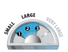
Expected Size?
Travel and Terrain Advice
- Avoid avalanche terrain during periods of heavy loading from new snow, wind, or rain.
Avalanche Problem 2: Persistent Slabs
What Elevation?
Which Slopes?
Chances of Avalanches?

Expected Size?

Rain penetrating the upper snowpack can percolate down to the halloween crust, awakening this layer.
Travel and Terrain Advice
- Avoid avalanche terrain during periods of heavy loading from new snow, wind, or rain.
Avalanche Problem 3: Loose Wet
What Elevation?

Which Slopes?
Chances of Avalanches?
Expected Size?
We have observed many loose wet avalanches over the last 24 hours. This trend will continue until the temperatures cool significantly.
Travel and Terrain Advice
- Avoid exposure to overhead avalanche terrain, large avalanches may reach the end of run out zones.
Avalanche Summary
A large and destructive avalanche cycle started yesterday. The peak of this cycle will be this morning, with approximately 30-40mm of rain in the start zones over the last 24 hours. We've observed lots of loose wet avalanches in the highway corridor and slab avalanches. This is the largest and most significant cycle we've seen so far this winter.
Snowpack Summary
150cm of new snow fell in the last seven days at tree line, followed by 40mm of rain. This combination has weakened the snowpack significantly. Below tree line the snowpack has become isothermal. At higher elevations storm and wind slabs have developed, and the upper snowpack layers are being saturated by the rain and warm temperatures.
Weather Forecast
Rain and wet flurries today, as the atmospheric river or pineapple slowly departs Rogers Pass. Freezing levels will lower, winds will slowly decrease and precipitation will gradually subside. However currently we have a moderate rain fall, extreme winds and high freezing levels!
Avalanche Forecasts in your Inbox
Avalanche Canada has switched to an RSS feed for its daily forecasts. This is a much more flexible method that allows automatic delivery to your email inbox, or to an RSS reader of your choice.
What are RSS feeds?
RSS (Really Simple Syndication) is a popular standardized file format allowing up-to-date delivery of web-based content. RSS feeds enable you to receive content updates from websites, delivered to your email through an RSS aggregator (such as blogtrottr.com) or viewed through applications called RSS readers (such as feedly.com).
Set up an RSS feed for your email:
Select a RSS aggregator
- Avalanche Bulletin - Glacier National Park URL:
http://www.avalanche.ca/api/forecasts/glacier.rss - Copy the url and paste it into the appropriate field of your RSS aggregator.
- Fill in your email address.
- Voila! Watch the Avalanche Canada forecast roll into your inbox.
Forecast Disclaimer
Avalanche Canada's Public Avalanche Bulletin, and other information and services provided by Avalanche Canada, are intended for personal and recreational purposes only.
**THIS INFORMATION IS PROVIDED "AS IS" AND IN NO EVENT SHALL THE PROVIDERS BE LIABLE FOR ANY DAMAGES, INCLUDING, WITHOUT LIMITATION, DAMAGES RESULTING FROM DISCOMFORT, INJURY, OR DEATH, CLAIMS BY THIRD PARTIES OR FOR OTHER SIMILAR COSTS, OR ANY SPECIAL, INCIDENTAL, OR CONSEQUENTIAL DAMAGES, ARISING OUT OF THE USE OF THE INFORMATION.**
The user acknowledges that it is impossible to accurately predict natural events such as avalanches in every instance, and uses the data in this bulletin with this always foremost in mind. The accuracy or reliability of the data is not guaranteed or warranted in any way and the Providers disclaim liability of any kind whatsoever, including, without limitation, liability for quality, performance, merchantability and fitness for a particular purpose arising out of the use, or inability to use the data.
Intense loading of start zones combined with warm temperatures and significant rain or snow fall, has created touchy storm slabs.