Avalanche Forecast
Avalanche Bulletin - Little Yoho

In general the snowpack is strong and we have seen the mid snowpack weak layers gain significant strength over the past two weeks. RIght now the main issue is windslabs in leeward pockets from the past 48 hours - they are small but could catch you.
Avalanche Problem 1: Wind Slabs
What Elevation?

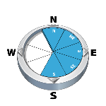
Which Slopes?
Chances of Avalanches?

Expected Size?

Travel and Terrain Advice
- Be careful with wind loaded pockets, especially near ridge crests and roll-overs.
Avalanche Problem 2: Persistent Slabs
What Elevation?

Which Slopes?

Chances of Avalanches?

Expected Size?

We continue to track three mid-snowpack weak layers from earlier this winter. They are bonding well and test results no longer show failures here. This problem continues to be in the back of our minds, but our confidence in the snowpack has improved.
Travel and Terrain Advice
- Ride large slopes one at a time and spot your partners from safe locations.
Avalanche Summary
Windslabs us to size 1.5 from explosives control at Sunshine Village. Otherwise no new avalanches reported.
Snowpack Summary
5 cm of loose snow on the surface at treeline with wind slabs forming in open areas at higher elevations. Three mid-pack weak layers of surface hoar and/or facets appear well bonded, but are worth keeping in mind on bigger slopes. Snowpack tests are showing no results on those layers.
Weather Forecast
Minor warming trend over the next few days, with highs reaching -2 by Thursday. Otherwise expect light flurries with no significant accumulations over the next few days. Overnight Tuesday will continue to be windy, with winds shifting to the southwest and slowing down on Wednesday.
Avalanche Forecasts in your Inbox
Avalanche Canada has switched to an RSS feed for its daily forecasts. This is a much more flexible method that allows automatic delivery to your email inbox, or to an RSS reader of your choice.
What are RSS feeds?
RSS (Really Simple Syndication) is a popular standardized file format allowing up-to-date delivery of web-based content. RSS feeds enable you to receive content updates from websites, delivered to your email through an RSS aggregator (such as blogtrottr.com) or viewed through applications called RSS readers (such as feedly.com).
Set up an RSS feed for your email:
Select a RSS aggregator
- Avalanche Bulletin - Little Yoho URL:
http://www.avalanche.ca/api/forecasts/little-yoho.rss - Copy the url and paste it into the appropriate field of your RSS aggregator.
- Fill in your email address.
- Voila! Watch the Avalanche Canada forecast roll into your inbox.
Forecast Disclaimer
Avalanche Canada's Public Avalanche Bulletin, and other information and services provided by Avalanche Canada, are intended for personal and recreational purposes only.
**THIS INFORMATION IS PROVIDED "AS IS" AND IN NO EVENT SHALL THE PROVIDERS BE LIABLE FOR ANY DAMAGES, INCLUDING, WITHOUT LIMITATION, DAMAGES RESULTING FROM DISCOMFORT, INJURY, OR DEATH, CLAIMS BY THIRD PARTIES OR FOR OTHER SIMILAR COSTS, OR ANY SPECIAL, INCIDENTAL, OR CONSEQUENTIAL DAMAGES, ARISING OUT OF THE USE OF THE INFORMATION.**
The user acknowledges that it is impossible to accurately predict natural events such as avalanches in every instance, and uses the data in this bulletin with this always foremost in mind. The accuracy or reliability of the data is not guaranteed or warranted in any way and the Providers disclaim liability of any kind whatsoever, including, without limitation, liability for quality, performance, merchantability and fitness for a particular purpose arising out of the use, or inability to use the data.
Fresh wind slabs exist in lee areas in the alpine. While they may not be very thick or particularly touchy, they certainly have the potential to carry you into an undesirable location (cliffs/terrain traps) if triggered in steep terrain.