Avalanche Forecast
Avalanche Bulletin - Little Yoho

The first major avalanche cycle of the season starts on Wed and peaks on Thurs. Avoid all avalanche terrain. There is a significant weak layer deep in the snowpack that is active and we expect widespread avalanche activity over the next two days.
Avalanche Problem 1: Persistent Slabs
What Elevation?

Which Slopes?

Chances of Avalanches?

Expected Size?
Travel and Terrain Advice
- Avoid all avalanche terrain.
Avalanche Problem 2: Wind Slabs
What Elevation?

Which Slopes?

Chances of Avalanches?
Expected Size?

Winds up to 100 km/hr are forecast for Wed and Thurs which will load the new snow onto leeward aspects. Windslabs should be expected near all ridges and gully areas and can be expected to become large once triggered.
Travel and Terrain Advice
- Avoid freshly wind loaded features.
Avalanche Problem 3: Loose Wet
What Elevation?
Which Slopes?
Chances of Avalanches?

Expected Size?

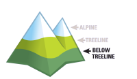
Warm temperatures and rain at low elevations will produce wet avalanches in gullies below treeline. Ice climbers in particular should avoid gully climbs on Wed and Thurs.
Avalanche Summary
No new avalanche activity observed or reported Tues in the Little Yoho valley, Lake Louise resort or Sunshine Village area. Mon saw significant avalanche activity with Lake Louise ski resort reporting 32 avalanches releasing from 38 target areas controlled; several large avalanches up to size 2.5 - this shows the potential of the Halloween crust.
Snowpack Summary
The Little Yoho valley has a 100cm snowpack at 1750m. The top 60cm is dry, settled storm snow overlying facets on the Halloween crust - this is the layer to watch. Snowpack tests indicate sudden collapse failures on this layer and propagation can be expected. Strong winds with this next storm will create windslabs in exposed areas at TL and above.
Weather Forecast
A strong westerly flow dominates the region with the Pineapple Express bringing a big warm up and rain for Wed and Thurs. Expect 20cm of fresh snow by Wed afternoon and warming through the day - by Wed night freezing levels will reach 2600m and Thurs will be a heavy storm day with rain, snow, warmth and strong winds. Cooling beings late Thurs.
Avalanche Forecasts in your Inbox
Avalanche Canada has switched to an RSS feed for its daily forecasts. This is a much more flexible method that allows automatic delivery to your email inbox, or to an RSS reader of your choice.
What are RSS feeds?
RSS (Really Simple Syndication) is a popular standardized file format allowing up-to-date delivery of web-based content. RSS feeds enable you to receive content updates from websites, delivered to your email through an RSS aggregator (such as blogtrottr.com) or viewed through applications called RSS readers (such as feedly.com).
Set up an RSS feed for your email:
Select a RSS aggregator
- Avalanche Bulletin - Little Yoho URL:
http://www.avalanche.ca/api/forecasts/little-yoho.rss - Copy the url and paste it into the appropriate field of your RSS aggregator.
- Fill in your email address.
- Voila! Watch the Avalanche Canada forecast roll into your inbox.
Forecast Disclaimer
Avalanche Canada's Public Avalanche Bulletin, and other information and services provided by Avalanche Canada, are intended for personal and recreational purposes only.
**THIS INFORMATION IS PROVIDED "AS IS" AND IN NO EVENT SHALL THE PROVIDERS BE LIABLE FOR ANY DAMAGES, INCLUDING, WITHOUT LIMITATION, DAMAGES RESULTING FROM DISCOMFORT, INJURY, OR DEATH, CLAIMS BY THIRD PARTIES OR FOR OTHER SIMILAR COSTS, OR ANY SPECIAL, INCIDENTAL, OR CONSEQUENTIAL DAMAGES, ARISING OUT OF THE USE OF THE INFORMATION.**
The user acknowledges that it is impossible to accurately predict natural events such as avalanches in every instance, and uses the data in this bulletin with this always foremost in mind. The accuracy or reliability of the data is not guaranteed or warranted in any way and the Providers disclaim liability of any kind whatsoever, including, without limitation, liability for quality, performance, merchantability and fitness for a particular purpose arising out of the use, or inability to use the data.
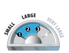
This is an active avalanche problem and is the main reason people should avoid all avalanche terrain for Wednesday and Thursday. The problem exists in most terrain and will become overloaded with the incoming storm. Watch overhead hazard.