Avalanche Forecast
Kootenay Boundary

A Special Public Avalanche Warning is in effect as large, destructive avalanches continue to fail throughout the region.
Don't over-think the current avalanche scenario. Stick to extremely low angle terrain and avoid any overhead hazards.
Avalanche Problem 1: Storm Slabs
What Elevation?

Which Slopes?

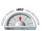
Chances of Avalanches?
Expected Size?

Travel and Terrain Advice
- The new snow will require several days to settle and stabilize.
- Storm slabs in motion will likely step down and produce large destructive avalanches.
- Avoid all avalanche terrain.
Avalanche Problem 2: Persistent Slabs
What Elevation?
Which Slopes?
Chances of Avalanches?
Expected Size?

Our complex snowpack is currently producing very large avalanches on deeply buried weak layers. Expert level knowledge and significant experience is required to venture into the backcountry at this time.
Travel and Terrain Advice
- Avoid exposure to overhead avalanche terrain, large avalanches may reach the end of run out zones.
- Only the most simple non-avalanche terrain free of overhead hazard is appropriate at this time
Avalanche Summary
On Tuesday a widespread natural avalanche cycle to size 2.5 was reported from all aspects and elevations as the upper snowpack adjusted to a new load and increasingly warm temperatures.
On Wednesday control work around Kootenay Pass produced very large avalanches to size 3.5 on southwest, south and southeast aspects. Natural avalanches ran to size 2.5 on southeast, east and northeast aspects. These avalanches may have started as storm slabs, but quickly stepped down to the mid-December and/or late November weak layers. An awesome MIN post from the same day also details some spooky skier-triggered avalanche activity around treeline in the Nelson area. Click here for details. At the time of publishing this bulletin, no new avalanche activity had been reported, but I don't expect conditions to have improved to any significant extent.
Looking forward, natural avalanche activity may taper-off somewhat; however, human triggering of large, destructive persistent slab avalanches at all elevation bands is expected to continue for the foreseeable future in many parts of the region.
Snowpack Summary
40 to 80 cm of recent snow is settling into a cohesive slab on top of the reactive January 5th interface which consists of a crust/surface hoar combination on steep southerly aspects and pure surface hoar on remaining aspects. The late December surface hoar also remains reactive and is now down 50 to 95 cm below the surface.
Adding to the complexity of the mid to upper snowpack is the mid-December surface hoar which is now 60 to 130 cm below the surface. This spooky interface continues to produce sudden snowpack test results and is most pronounced at treeline, but is also present below treeline. The overlying slab is now deep, dense and destructive.
Two laminated crusts created by rain events in late November lay just below the mid-December interface, and may co-exist with facets. In shallow, rocky terrain the mid-December surface hoar and the late November crust seem to be reacting together which is a volatile combination.
Weather Forecast
Friday: 3-7cm of the new snow / Light to moderate westerly winds / Freezing level at 700m
Saturday: Mix of sun and cloud / Light westerly winds / Freezing level at 800m
Sunday: Mostly clear skies / Light southwest winds / Inversion with valley temperatures hovering around freezing and alpine temperatures reaching 2600m
Avalanche Forecasts in your Inbox
Avalanche Canada has switched to an RSS feed for its daily forecasts. This is a much more flexible method that allows automatic delivery to your email inbox, or to an RSS reader of your choice.
What are RSS feeds?
RSS (Really Simple Syndication) is a popular standardized file format allowing up-to-date delivery of web-based content. RSS feeds enable you to receive content updates from websites, delivered to your email through an RSS aggregator (such as blogtrottr.com) or viewed through applications called RSS readers (such as feedly.com).
Set up an RSS feed for your email:
Select a RSS aggregator
- Kootenay Boundary URL:
http://www.avalanche.ca/api/forecasts/kootenay-boundary.rss - Copy the url and paste it into the appropriate field of your RSS aggregator.
- Fill in your email address.
- Voila! Watch the Avalanche Canada forecast roll into your inbox.
Forecast Disclaimer
Avalanche Canada's Public Avalanche Bulletin, and other information and services provided by Avalanche Canada, are intended for personal and recreational purposes only.
**THIS INFORMATION IS PROVIDED "AS IS" AND IN NO EVENT SHALL THE PROVIDERS BE LIABLE FOR ANY DAMAGES, INCLUDING, WITHOUT LIMITATION, DAMAGES RESULTING FROM DISCOMFORT, INJURY, OR DEATH, CLAIMS BY THIRD PARTIES OR FOR OTHER SIMILAR COSTS, OR ANY SPECIAL, INCIDENTAL, OR CONSEQUENTIAL DAMAGES, ARISING OUT OF THE USE OF THE INFORMATION.**
The user acknowledges that it is impossible to accurately predict natural events such as avalanches in every instance, and uses the data in this bulletin with this always foremost in mind. The accuracy or reliability of the data is not guaranteed or warranted in any way and the Providers disclaim liability of any kind whatsoever, including, without limitation, liability for quality, performance, merchantability and fitness for a particular purpose arising out of the use, or inability to use the data.
40 to 60 cm of recent storm snow has settled into a reactive slab that rests on the early January weak layer. Large natural and human triggered storm slab avalanches remain likely, and may "step-down" to deeper, more destructive layers.