Avalanche Forecast
Kananaskis Country, Alberta Parks

25cm of snow in the past 48hrs and more forecast to fall overnight. Watch for the windslabs to become more reactive on sunday. If the sun comes out, avoid solar aspects.
Avalanche Problem 1: Wind Slabs
What Elevation?

Which Slopes?

Chances of Avalanches?

Expected Size?

Travel and Terrain Advice
- Avoid lee and cross-loaded terrain near ridge crests.
- Give cornices a wide berth when travelling on or below ridges.
Avalanche Problem 2: Cornices
What Elevation?

Which Slopes?
Chances of Avalanches?

Expected Size?

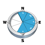
Cornices are large and looming and become weak with daytime heating. New snow on Saturday combined with warm temps on Sunday may make these features prone to collapse.
Travel and Terrain Advice
- Cornices become weak with daytime heating, so travel early on exposed slopes.
Avalanche Problem 3: Persistent Slabs
What Elevation?
Which Slopes?
Chances of Avalanches?

Expected Size?
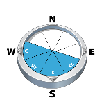
Lots of variability on this interface down 50-60cm on solar aspects. Stability tests have been improving but we still have limited confidence on these aspects until a full melt freeze cycle occurs.
Travel and Terrain Advice
- Carefully evaluate big terrain features by digging and testing on adjacent, safe slopes.
Avalanche Summary
Report on the MIN of a skier accidental sz 2 avalanche below the Window Couloir on french creek. Otherwise no new natural avalanche activity.
Snowpack Summary
SW winds increased in alpine overnight and into the morning building windslabs 20-25cm thick in lee features in the Alpine and treeline. The recent snow (10-15cm at treeline and above on Saturday and 10cm on Friday) is overlying a supportive MFC that is 4-6cm thick up to 2200m and up to the peaks on solar aspects We are finding good "dust on crust" skiing on top of this crust. Corncies are LARGE right now and a few have collapsed recently with the warmer weather. Start early and be home early before the snow begins to melt and settle and loose stability in the warmer temps or the solar radiation.
Weather Forecast
A few more cm of snow is forecast to fall overnight with upper level winds still in the Moderate SW range. This new snow will add to the 15cm that fell throghout the day on Saturday. If we do get more that the 4cm is forecast, we may see avalanche danger push back into the considerable range in the alpine. The freezing level on sunday is forecast to be at 2300m so as conditions warm up expect stability to decrease and the new snow to rapidly settle.
Avalanche Forecasts in your Inbox
Avalanche Canada has switched to an RSS feed for its daily forecasts. This is a much more flexible method that allows automatic delivery to your email inbox, or to an RSS reader of your choice.
What are RSS feeds?
RSS (Really Simple Syndication) is a popular standardized file format allowing up-to-date delivery of web-based content. RSS feeds enable you to receive content updates from websites, delivered to your email through an RSS aggregator (such as blogtrottr.com) or viewed through applications called RSS readers (such as feedly.com).
Set up an RSS feed for your email:
Select a RSS aggregator
- Kananaskis Country, Alberta Parks URL:
http://www.avalanche.ca/api/forecasts/kananaskis.rss - Copy the url and paste it into the appropriate field of your RSS aggregator.
- Fill in your email address.
- Voila! Watch the Avalanche Canada forecast roll into your inbox.
Forecast Disclaimer
Avalanche Canada's Public Avalanche Bulletin, and other information and services provided by Avalanche Canada, are intended for personal and recreational purposes only.
**THIS INFORMATION IS PROVIDED "AS IS" AND IN NO EVENT SHALL THE PROVIDERS BE LIABLE FOR ANY DAMAGES, INCLUDING, WITHOUT LIMITATION, DAMAGES RESULTING FROM DISCOMFORT, INJURY, OR DEATH, CLAIMS BY THIRD PARTIES OR FOR OTHER SIMILAR COSTS, OR ANY SPECIAL, INCIDENTAL, OR CONSEQUENTIAL DAMAGES, ARISING OUT OF THE USE OF THE INFORMATION.**
The user acknowledges that it is impossible to accurately predict natural events such as avalanches in every instance, and uses the data in this bulletin with this always foremost in mind. The accuracy or reliability of the data is not guaranteed or warranted in any way and the Providers disclaim liability of any kind whatsoever, including, without limitation, liability for quality, performance, merchantability and fitness for a particular purpose arising out of the use, or inability to use the data.
Windslabs up to 25cm thick in lee and crossloaded features. Lots of snow is currently available for transport so pay attention to localized wind affect.