Avalanche Forecast
Kananaskis Country, Alberta Parks

New snow is coming tomorrow. Expect great skiing if we get the forecasted amounts.
Avalanche Problem 1: Wind Slabs
What Elevation?

Which Slopes?

Chances of Avalanches?

Expected Size?

Travel and Terrain Advice
- Avoid freshly wind loaded features.
Avalanche Problem 2: Loose Dry
What Elevation?
Which Slopes?

Chances of Avalanches?
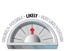
Expected Size?

This will be more of an issue in areas that has a frozen crust underneath. They could run far and fast.
Travel and Terrain Advice
- Avoid travelling under cliffs that are exposed to sluffing from above.
- Sluffs will be easy to trigger in steep terrain that is sheltered from the wind
Avalanche Problem 3: Storm Slabs
What Elevation?
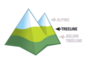
Which Slopes?
Chances of Avalanches?

Expected Size?
As the storm starts, the new snow will bond quickly as the remaining heat escapes from the snowpack. The air temp will also play a role especially if it snows before it cools off completely.
Avalanche Summary
A couple of small, cornice triggered loose wet avalanches were noted today. Their exact age is unknown, but suspected in the last 36 hours.
Snowpack Summary
Freezing levels went very high today. One of the radio repeater sites recorded a temp of +4 by mid afternoon. Only high, true north aspects are escaping the heat and moist snow. Expect a widespread crust pretty much everywhere. It will be more pronounced at low elevations and/or solar aspects. The freeze thaw cycle is helping the upper snowpack consolidate and become stronger. The deeper layers are deep enough that they'll remain unchanged from the warming cycle. Cornices and wind lips have been collapsing lately as well.
Weather Forecast
We're expecting a storm to roll through tonight with snow starting by early morning. Overnight lows will fall to -6, and by tomorrow, they'll fall further to -10 at treeline. The first pulse of this storm will bring us 21cm of snow by late day tomorrow. Another pulse will follow on saturday, but it will only leave 5cm. The winds will spike early on in the storm and max out at 45km/hr.
Avalanche Forecasts in your Inbox
Avalanche Canada has switched to an RSS feed for its daily forecasts. This is a much more flexible method that allows automatic delivery to your email inbox, or to an RSS reader of your choice.
What are RSS feeds?
RSS (Really Simple Syndication) is a popular standardized file format allowing up-to-date delivery of web-based content. RSS feeds enable you to receive content updates from websites, delivered to your email through an RSS aggregator (such as blogtrottr.com) or viewed through applications called RSS readers (such as feedly.com).
Set up an RSS feed for your email:
Select a RSS aggregator
- Kananaskis Country, Alberta Parks URL:
http://www.avalanche.ca/api/forecasts/kananaskis.rss - Copy the url and paste it into the appropriate field of your RSS aggregator.
- Fill in your email address.
- Voila! Watch the Avalanche Canada forecast roll into your inbox.
Forecast Disclaimer
Avalanche Canada's Public Avalanche Bulletin, and other information and services provided by Avalanche Canada, are intended for personal and recreational purposes only.
**THIS INFORMATION IS PROVIDED "AS IS" AND IN NO EVENT SHALL THE PROVIDERS BE LIABLE FOR ANY DAMAGES, INCLUDING, WITHOUT LIMITATION, DAMAGES RESULTING FROM DISCOMFORT, INJURY, OR DEATH, CLAIMS BY THIRD PARTIES OR FOR OTHER SIMILAR COSTS, OR ANY SPECIAL, INCIDENTAL, OR CONSEQUENTIAL DAMAGES, ARISING OUT OF THE USE OF THE INFORMATION.**
The user acknowledges that it is impossible to accurately predict natural events such as avalanches in every instance, and uses the data in this bulletin with this always foremost in mind. The accuracy or reliability of the data is not guaranteed or warranted in any way and the Providers disclaim liability of any kind whatsoever, including, without limitation, liability for quality, performance, merchantability and fitness for a particular purpose arising out of the use, or inability to use the data.
These will be fresh windslabs formed from gusting winds. They may slide easily if sitting on a crust.