Avalanche Forecast
Kananaskis Country, Alberta Parks

A heavy snowfall warning is in effect but not all of the models are in agreement. We may see up to 10cm of snow overnight with the majority of this new snow falling in the eastern regions.
Avalanche Problem 1: Wind Slabs
What Elevation?

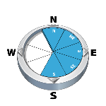
Which Slopes?
Chances of Avalanches?

Expected Size?

Travel and Terrain Advice
- Use caution in lee areas. Recent wind loading has created wind slabs.
- Evaluate unsupported slopes critically.
Avalanche Problem 2: Deep Persistent Slabs
What Elevation?
Which Slopes?

Chances of Avalanches?
Expected Size?

Large triggers are a concern. It's safe to say we're in the "low probability/high consequence" situation. Avoid thin areas.
Travel and Terrain Advice
- Be aware of the potential for full depth avalanches due to deeply buried weak layers.
Avalanche Summary
No new avalanche activity has been observed in the past 24hrs.
Snowpack Summary
This week so far we have only seen 10cm of new snow at the higher elevations. This snow has been moved around by the NW flow adding load to the previous existing windslabs that had formed across the region. Forecasters can confirm that wind affected snow is the norm. Any above treeline terrain has been pummeled by the winds making travel fast but skiing not so appealing. Cold temps have also facetted out the upper snowpack below treeline making shallow areas very weak. The midpack is well settled but we are in need of new snow for a bit of a re-set within the snowpack.
Weather Forecast
We are expecting a weak system to cross over the region tonight and give us a few flurries but not too much in the way of accumulations. By Sunday we are HOPEFUL that 20cm of new snow will have fallen with very little wind affect. Temperatures are again supposed to drop back towards -20 by the weekend with light - moderate winds out of the NW.
Avalanche Forecasts in your Inbox
Avalanche Canada has switched to an RSS feed for its daily forecasts. This is a much more flexible method that allows automatic delivery to your email inbox, or to an RSS reader of your choice.
What are RSS feeds?
RSS (Really Simple Syndication) is a popular standardized file format allowing up-to-date delivery of web-based content. RSS feeds enable you to receive content updates from websites, delivered to your email through an RSS aggregator (such as blogtrottr.com) or viewed through applications called RSS readers (such as feedly.com).
Set up an RSS feed for your email:
Select a RSS aggregator
- Kananaskis Country, Alberta Parks URL:
http://www.avalanche.ca/api/forecasts/kananaskis.rss - Copy the url and paste it into the appropriate field of your RSS aggregator.
- Fill in your email address.
- Voila! Watch the Avalanche Canada forecast roll into your inbox.
Forecast Disclaimer
Avalanche Canada's Public Avalanche Bulletin, and other information and services provided by Avalanche Canada, are intended for personal and recreational purposes only.
**THIS INFORMATION IS PROVIDED "AS IS" AND IN NO EVENT SHALL THE PROVIDERS BE LIABLE FOR ANY DAMAGES, INCLUDING, WITHOUT LIMITATION, DAMAGES RESULTING FROM DISCOMFORT, INJURY, OR DEATH, CLAIMS BY THIRD PARTIES OR FOR OTHER SIMILAR COSTS, OR ANY SPECIAL, INCIDENTAL, OR CONSEQUENTIAL DAMAGES, ARISING OUT OF THE USE OF THE INFORMATION.**
The user acknowledges that it is impossible to accurately predict natural events such as avalanches in every instance, and uses the data in this bulletin with this always foremost in mind. The accuracy or reliability of the data is not guaranteed or warranted in any way and the Providers disclaim liability of any kind whatsoever, including, without limitation, liability for quality, performance, merchantability and fitness for a particular purpose arising out of the use, or inability to use the data.
Windslabs are the theme in the alpine and treeline. Last weeks strong NW flow has created windslabs 10-40cm thick. Be aware of wide propagation potential