Date issued

Apr 11, 2018 - 8:00 AM

Valid until

Apr 12, 2018 - 8:00 AM

Prepared by

mark herbison

Rising freezing level and solar input will increase avalanche hazard as the day progresses.

Regular season
Wednesday - April 11, 2018
Alpine

2 - Moderate

Heightened avalanche conditions on specific terrain features. Evaluate snow and terrain carefully; identify features of concern.

Natural avalanches unlikely; human-triggered avalanches possible.

Small avalanches in specific areas; or large avalanches in isolated areas.

Treeline

2 - Moderate

Heightened avalanche conditions on specific terrain features. Evaluate snow and terrain carefully; identify features of concern.

Natural avalanches unlikely; human-triggered avalanches possible.

Small avalanches in specific areas; or large avalanches in isolated areas.

Below Treeline

2 - Moderate

Heightened avalanche conditions on specific terrain features. Evaluate snow and terrain carefully; identify features of concern.

Natural avalanches unlikely; human-triggered avalanches possible.

Small avalanches in specific areas; or large avalanches in isolated areas.

Thursday - April 12, 2018
Alpine

2 - Moderate

Heightened avalanche conditions on specific terrain features. Evaluate snow and terrain carefully; identify features of concern.

Natural avalanches unlikely; human-triggered avalanches possible.

Small avalanches in specific areas; or large avalanches in isolated areas.

Treeline

2 - Moderate

Heightened avalanche conditions on specific terrain features. Evaluate snow and terrain carefully; identify features of concern.

Natural avalanches unlikely; human-triggered avalanches possible.

Small avalanches in specific areas; or large avalanches in isolated areas.

Below Treeline

2 - Moderate

Heightened avalanche conditions on specific terrain features. Evaluate snow and terrain carefully; identify features of concern.

Natural avalanches unlikely; human-triggered avalanches possible.

Small avalanches in specific areas; or large avalanches in isolated areas.

Friday - April 13, 2018
Alpine

3 - Considerable

Dangerous avalanche conditions. Careful snowpack evaluation,cautious route-finding and conservative decision-making essential.

Natural avalanches possible;human-triggered avalanches likely.

Small avalanches in many areas; or large avalanches in specific areas; or very large avalanches in isolated areas.

Treeline

2 - Moderate

Heightened avalanche conditions on specific terrain features. Evaluate snow and terrain carefully; identify features of concern.

Natural avalanches unlikely; human-triggered avalanches possible.

Small avalanches in specific areas; or large avalanches in isolated areas.

Below Treeline

2 - Moderate

Heightened avalanche conditions on specific terrain features. Evaluate snow and terrain carefully; identify features of concern.

Natural avalanches unlikely; human-triggered avalanches possible.

Small avalanches in specific areas; or large avalanches in isolated areas.

Avalanche Problem 1: Loose Wet

What Elevation?
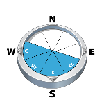
Which Slopes?
Chances of Avalanches?
Expected Size?

The sun is expected to make an appearance today which will heat up solar aspects quickly and weaken the surface snow, resulting in potential avalanches.

Travel and Terrain Advice
  • Use extra caution on slopes if the snow is moist or wet.
  • Avoid exposure to overhead solar avalanche terrain, avalanches may reach the end of run out zones.

Avalanche Problem 2: Persistent Slabs

What Elevation?
Which Slopes?
Chances of Avalanches?
Expected Size?

70-90cm of settled snow sits on the mid March crust/facet combo and fails suddenly in the moderate-hard range in stability tests on solar aspects.

Travel and Terrain Advice
  • Be cautious with convexities and steep slopes on solar aspects.

Avalanche Summary

Numerous natural loose wet avalanches yesterday from tree line and below due to the warm temps and rain to 2300m.

Artillery avalanche control produced results up to sz 2.5 along the highway corridor yesterday.

Avalanche activity has tapered off with a decent overnight freeze, but use caution on southerly aspects if the solar radiation is strong.

Snowpack Summary

A fresh surface crust formed by yesterdays rain up to 2300m and cool temps overnight exists on all aspects, with 5cm of new snow at higher elevations. Moist snow may be found below the crust in the top 20cm of the snowpack. Well-settled mid and lower snowpack with the Mar 15 crust complex down 70-90cm on solar aspects.

Weather Forecast

A mix of sun and cloud for the day with isolated convective flurries in the afternoon. Temps will range from 3 to -3 as the freezing level rises to1700m. Wind will be light from the south. Several pulses of precipitation will reach our area on Thursday and Friday with freezing levels around 1800m.

Danger Ratings Explained

1 - Low

Generally safe avalanche conditions. Watch for unstable snow on isolated terrain features.

Natural and human-triggered avalanches unlikely.

Small avalanches in isolated areas or extreme terrain.

2 - Moderate

Heightened avalanche conditions on specific terrain features. Evaluate snow and terrain carefully; identify features of concern.

Natural avalanches unlikely; human-triggered avalanches possible.

Small avalanches in specific areas; or large avalanches in isolated areas.

3 - Considerable

Dangerous avalanche conditions. Careful snowpack evaluation, cautious route-finding and conservative decision-making essential.

Natural avalanches possible; human-triggered avalanches likely.

Small avalanches in many areas; or large avalanches in specific areas; or very large avalanches in isolated areas.

4 - High

Very dangerous avalanche conditions. Travel in avalanche terrain not recommended.

Natural avalanches likely; human-triggered avalanches very likely.

Large avalanches in many areas; or very large avalanches in specific areas.

5 - Extreme

Avoid all avalanche terrain.

Natural and human-triggered avalanches certain.

Large to very large avalanches in many areas.

Avalanche Forecasts in your Inbox

Avalanche Canada has switched to an RSS feed for its daily forecasts. This is a much more flexible method that allows automatic delivery to your email inbox, or to an RSS reader of your choice.

What are RSS feeds?

RSS (Really Simple Syndication) is a popular standardized file format allowing up-to-date delivery of web-based content. RSS feeds enable you to receive content updates from websites, delivered to your email through an RSS aggregator (such as blogtrottr.com) or viewed through applications called RSS readers (such as feedly.com).

Set up an RSS feed for your email:

Select a RSS aggregator

  1. Avalanche Bulletin - Glacier National Park URL: http://www.avalanche.ca/api/forecasts/glacier.rss
  2. Copy the url and paste it into the appropriate field of your RSS aggregator.
  3. Fill in your email address.
  4. Voila! Watch the Avalanche Canada forecast roll into your inbox.

Forecast Disclaimer

Avalanche Canada's Public Avalanche Bulletin, and other information and services provided by Avalanche Canada, are intended for personal and recreational purposes only.

**THIS INFORMATION IS PROVIDED "AS IS" AND IN NO EVENT SHALL THE PROVIDERS BE LIABLE FOR ANY DAMAGES, INCLUDING, WITHOUT LIMITATION, DAMAGES RESULTING FROM DISCOMFORT, INJURY, OR DEATH, CLAIMS BY THIRD PARTIES OR FOR OTHER SIMILAR COSTS, OR ANY SPECIAL, INCIDENTAL, OR CONSEQUENTIAL DAMAGES, ARISING OUT OF THE USE OF THE INFORMATION.**

The user acknowledges that it is impossible to accurately predict natural events such as avalanches in every instance, and uses the data in this bulletin with this always foremost in mind. The accuracy or reliability of the data is not guaranteed or warranted in any way and the Providers disclaim liability of any kind whatsoever, including, without limitation, liability for quality, performance, merchantability and fitness for a particular purpose arising out of the use, or inability to use the data.