Avalanche Forecast
Avalanche Bulletin - Glacier National Park

Danger ratings have been reduced but it is still possible for large human triggered avalanches. Evaluate the terrain and the snowpack carefully.
Avalanche Problem 1: Wind Slabs
What Elevation?

Which Slopes?

Chances of Avalanches?

Expected Size?

Travel and Terrain Advice
- Be careful with wind loaded pockets, especially near ridge crests and roll-overs.
- Watch for whumpfing, hollow sounds, and shooting cracks.
Avalanche Problem 2: Cornices
What Elevation?

Which Slopes?
Chances of Avalanches?
Expected Size?
Cornices have been failing steadily over the past week. Cold temperatures and solar input are contributing to these failures with brittle fractures of the snow as temperatures fluctuate.
Travel and Terrain Advice
- Avoid travel on slopes that are exposed to cornices overhead.
- Cornices become weak with daytime heating.
Avalanche Problem 3: Persistent Slabs
What Elevation?
Which Slopes?
Chances of Avalanches?

Expected Size?
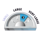
Persistent weak layers continue to linger and are most likely triggered in steep, shallow, rocky, unsupported terrain features. Larger triggers such as cornice fall may also wake these deeper weak layers resulting in larger avalanches.
Travel and Terrain Advice
- Avoid thin, rocky or unsupported slopes.
Avalanche Summary
No new avalanches observed yesterday.
Skier controlled size 2.5 wind slab on Mt. Sifton and several skier controlled size 1.0 loose dry sluffs in the Hermit slide path two days ago.
Several cornice failures earlier this week up to size 2.5.
Snowpack Summary
Cold temps promoting facetting of the upper snowpack. Previous strong NE winds have formed reverse loaded cornices. Windslab can be expected in the alpine and exposed areas well into treeline. On solar aspects, a crust is buried 40cm. Persistent weak layers from January and December are now buried 150-200cm.
Weather Forecast
Another abnormally cold day in Rogers Pass, mainly cloudy skies with periods of sun. No snow in the forecast, temps ranging between -23 to -16 with 10-20km/h southwest winds. Friday will be the day of change in the weather with warming temps and 10-15cm of snow by Sunday.
Avalanche Forecasts in your Inbox
Avalanche Canada has switched to an RSS feed for its daily forecasts. This is a much more flexible method that allows automatic delivery to your email inbox, or to an RSS reader of your choice.
What are RSS feeds?
RSS (Really Simple Syndication) is a popular standardized file format allowing up-to-date delivery of web-based content. RSS feeds enable you to receive content updates from websites, delivered to your email through an RSS aggregator (such as blogtrottr.com) or viewed through applications called RSS readers (such as feedly.com).
Set up an RSS feed for your email:
Select a RSS aggregator
- Avalanche Bulletin - Glacier National Park URL:
http://www.avalanche.ca/api/forecasts/glacier.rss - Copy the url and paste it into the appropriate field of your RSS aggregator.
- Fill in your email address.
- Voila! Watch the Avalanche Canada forecast roll into your inbox.
Forecast Disclaimer
Avalanche Canada's Public Avalanche Bulletin, and other information and services provided by Avalanche Canada, are intended for personal and recreational purposes only.
**THIS INFORMATION IS PROVIDED "AS IS" AND IN NO EVENT SHALL THE PROVIDERS BE LIABLE FOR ANY DAMAGES, INCLUDING, WITHOUT LIMITATION, DAMAGES RESULTING FROM DISCOMFORT, INJURY, OR DEATH, CLAIMS BY THIRD PARTIES OR FOR OTHER SIMILAR COSTS, OR ANY SPECIAL, INCIDENTAL, OR CONSEQUENTIAL DAMAGES, ARISING OUT OF THE USE OF THE INFORMATION.**
The user acknowledges that it is impossible to accurately predict natural events such as avalanches in every instance, and uses the data in this bulletin with this always foremost in mind. The accuracy or reliability of the data is not guaranteed or warranted in any way and the Providers disclaim liability of any kind whatsoever, including, without limitation, liability for quality, performance, merchantability and fitness for a particular purpose arising out of the use, or inability to use the data.
Previous strong northerly winds have formed reverse loaded windslab at and above treeline. Windslab avalanches up to size 2.5 have been triggered by skiers or failing naturally. Avoid exposing yourself to overhead hazard.