Avalanche Forecast
Avalanche Bulletin - Glacier National Park

Sunny skies and prolonged solar radiation could take a toll on the snowpack, weakening cornices and southerly facing aspects.
Conservative terrain choices are appropriate for the day.
Avalanche Problem 1: Storm Slabs
What Elevation?

Which Slopes?

Chances of Avalanches?

Expected Size?

Travel and Terrain Advice
- If triggered the storm slabs may step down to deeper layers resulting in large avalanches.
- Use caution in lee areas in the alpine and treeline. Storm snow is forming reactive slabs.
Avalanche Problem 2: Persistent Slabs
What Elevation?
Which Slopes?
Chances of Avalanches?

Expected Size?
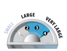
These slabs will be most susceptible to triggering in shallow areas. This type of instability will linger for a while yet. The significant storms seen recently have overloaded these layers, priming slopes to fail only awaiting a trigger.
Travel and Terrain Advice
- Be aware of the potential for large avalanches due to the presence of buried surface hoar.
- Avoid thin, rocky or unsupported slopes.
Avalanche Problem 3: Cornices
What Elevation?

Which Slopes?
Chances of Avalanches?
Expected Size?
Cornices have become reactive in the last week. Strong winds, fluctuating temperatures, significant snowfall and strong solar radiation has contributed to these loitering hazards failing.
Travel and Terrain Advice
- Cornices become weak with prolonged solar radiation, avoid traveling under these large hazards.
- Minimize exposure to overhead hazard from cornices.
Avalanche Summary
Numerous avalanches observed yesterday along highway corridor up to size 3.0.
Three days ago a group ascending MacDonald West Shoulder #4 remotely trigger a size 3.0 into NRC Gully from 10m away, the dust cloud settled within a few hundred meters of the highway. No one was involved in the avalanche.
Snowpack Summary
7cm of snow overnight, 40cm in the past two days brings to height of snow to 335cm at 1900m. Previous southerly winds have created pockets of wind slab in the alpine and exposed tree line areas which is now covered by a thin layer of snow. Persistent weak layers are now buried 150-200cm and a sun crust on steep solar aspects is down 30-50cm.
Weather Forecast
Don't forget to 'slip, slap, slop' your florescent green zinc sun screen on, as today will bring prolonged periods of sun with some cloudy periods. No snow in the forecast, temps ranging from -7 to -15 with 15-30km/hr westerly winds. Snow starting late this evening with 10-15cm by Saturday night with cold temps for Sunday into next week.
Avalanche Forecasts in your Inbox
Avalanche Canada has switched to an RSS feed for its daily forecasts. This is a much more flexible method that allows automatic delivery to your email inbox, or to an RSS reader of your choice.
What are RSS feeds?
RSS (Really Simple Syndication) is a popular standardized file format allowing up-to-date delivery of web-based content. RSS feeds enable you to receive content updates from websites, delivered to your email through an RSS aggregator (such as blogtrottr.com) or viewed through applications called RSS readers (such as feedly.com).
Set up an RSS feed for your email:
Select a RSS aggregator
- Avalanche Bulletin - Glacier National Park URL:
http://www.avalanche.ca/api/forecasts/glacier.rss - Copy the url and paste it into the appropriate field of your RSS aggregator.
- Fill in your email address.
- Voila! Watch the Avalanche Canada forecast roll into your inbox.
Forecast Disclaimer
Avalanche Canada's Public Avalanche Bulletin, and other information and services provided by Avalanche Canada, are intended for personal and recreational purposes only.
**THIS INFORMATION IS PROVIDED "AS IS" AND IN NO EVENT SHALL THE PROVIDERS BE LIABLE FOR ANY DAMAGES, INCLUDING, WITHOUT LIMITATION, DAMAGES RESULTING FROM DISCOMFORT, INJURY, OR DEATH, CLAIMS BY THIRD PARTIES OR FOR OTHER SIMILAR COSTS, OR ANY SPECIAL, INCIDENTAL, OR CONSEQUENTIAL DAMAGES, ARISING OUT OF THE USE OF THE INFORMATION.**
The user acknowledges that it is impossible to accurately predict natural events such as avalanches in every instance, and uses the data in this bulletin with this always foremost in mind. The accuracy or reliability of the data is not guaranteed or warranted in any way and the Providers disclaim liability of any kind whatsoever, including, without limitation, liability for quality, performance, merchantability and fitness for a particular purpose arising out of the use, or inability to use the data.
40cm in 48hrs, previous moderate winds have redistributed it into pockets of wind slab in the alpine and exposed treeline locations. Expect the storm slab to be most reactive along ridge lines, convexities and in steep unsupported terrain.