Date issued

Nov 17, 2017 - 8:06 AM

Valid until

Nov 18, 2017 - 8:00 AM

Prepared by

percy woods

Avalanches now have the potential to run to valley bottom in places like Connaught Creek.

Regular season
Thursday - November 16, 2017
Alpine

3 - Considerable

Dangerous avalanche conditions. Careful snowpack evaluation,cautious route-finding and conservative decision-making essential.

Natural avalanches possible;human-triggered avalanches likely.

Small avalanches in many areas; or large avalanches in specific areas; or very large avalanches in isolated areas.

Treeline

3 - Considerable

Dangerous avalanche conditions. Careful snowpack evaluation,cautious route-finding and conservative decision-making essential.

Natural avalanches possible;human-triggered avalanches likely.

Small avalanches in many areas; or large avalanches in specific areas; or very large avalanches in isolated areas.

Below Treeline

2 - Moderate

Heightened avalanche conditions on specific terrain features. Evaluate snow and terrain carefully; identify features of concern.

Natural avalanches unlikely; human-triggered avalanches possible.

Small avalanches in specific areas; or large avalanches in isolated areas.

Friday - November 17, 2017
Alpine

3 - Considerable

Dangerous avalanche conditions. Careful snowpack evaluation,cautious route-finding and conservative decision-making essential.

Natural avalanches possible;human-triggered avalanches likely.

Small avalanches in many areas; or large avalanches in specific areas; or very large avalanches in isolated areas.

Treeline

3 - Considerable

Dangerous avalanche conditions. Careful snowpack evaluation,cautious route-finding and conservative decision-making essential.

Natural avalanches possible;human-triggered avalanches likely.

Small avalanches in many areas; or large avalanches in specific areas; or very large avalanches in isolated areas.

Below Treeline

2 - Moderate

Heightened avalanche conditions on specific terrain features. Evaluate snow and terrain carefully; identify features of concern.

Natural avalanches unlikely; human-triggered avalanches possible.

Small avalanches in specific areas; or large avalanches in isolated areas.

Saturday - November 18, 2017
Alpine

3 - Considerable

Dangerous avalanche conditions. Careful snowpack evaluation,cautious route-finding and conservative decision-making essential.

Natural avalanches possible;human-triggered avalanches likely.

Small avalanches in many areas; or large avalanches in specific areas; or very large avalanches in isolated areas.

Treeline

2 - Moderate

Heightened avalanche conditions on specific terrain features. Evaluate snow and terrain carefully; identify features of concern.

Natural avalanches unlikely; human-triggered avalanches possible.

Small avalanches in specific areas; or large avalanches in isolated areas.

Below Treeline

2 - Moderate

Heightened avalanche conditions on specific terrain features. Evaluate snow and terrain carefully; identify features of concern.

Natural avalanches unlikely; human-triggered avalanches possible.

Small avalanches in specific areas; or large avalanches in isolated areas.

Avalanche Problem 1: Storm Slabs

What Elevation?
Which Slopes?
Chances of Avalanches?
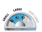
Expected Size?

70cm+ covers the November 9th interface. The storm slab will need a few days to bond to old snow surfaces. The storm slab is going to be a problem to watch out for coming into this weekend.

Travel and Terrain Advice
  • The new snow will require several days to settle and stabilize.
  • Minimize overhead exposure during periods of heavy loading from new snow, wind.

Avalanche Summary

Five avalanches to size 2.0 recorded off of Mt MacDonald in the last 24hrs. Slides to size 2 reported off Cheops running onto the fan on Wednesday.

Snowpack Summary

Upwards of 50cm of storm snow in the last 48hrs in addition to the storms of earlier this week. This rapid loading has lead to widespread storm slab formation at and above treeline. The Halloween crust is down around 70cm and the November 9th and 13th interfaces will be found in the top 70cm. Snowpack thins quickly below 1700m.

Weather Forecast

Moderate W'ly winds gusting to strong along with continued precipitation are forecast for today. Moderate gusting to strong wind from the SW are expected through the weekend. This will lead to continued storm slab formation and more touchy avalanche conditions.

Danger Ratings Explained

1 - Low

Generally safe avalanche conditions. Watch for unstable snow on isolated terrain features.

Natural and human-triggered avalanches unlikely.

Small avalanches in isolated areas or extreme terrain.

2 - Moderate

Heightened avalanche conditions on specific terrain features. Evaluate snow and terrain carefully; identify features of concern.

Natural avalanches unlikely; human-triggered avalanches possible.

Small avalanches in specific areas; or large avalanches in isolated areas.

3 - Considerable

Dangerous avalanche conditions. Careful snowpack evaluation, cautious route-finding and conservative decision-making essential.

Natural avalanches possible; human-triggered avalanches likely.

Small avalanches in many areas; or large avalanches in specific areas; or very large avalanches in isolated areas.

4 - High

Very dangerous avalanche conditions. Travel in avalanche terrain not recommended.

Natural avalanches likely; human-triggered avalanches very likely.

Large avalanches in many areas; or very large avalanches in specific areas.

5 - Extreme

Avoid all avalanche terrain.

Natural and human-triggered avalanches certain.

Large to very large avalanches in many areas.

Avalanche Forecasts in your Inbox

Avalanche Canada has switched to an RSS feed for its daily forecasts. This is a much more flexible method that allows automatic delivery to your email inbox, or to an RSS reader of your choice.

What are RSS feeds?

RSS (Really Simple Syndication) is a popular standardized file format allowing up-to-date delivery of web-based content. RSS feeds enable you to receive content updates from websites, delivered to your email through an RSS aggregator (such as blogtrottr.com) or viewed through applications called RSS readers (such as feedly.com).

Set up an RSS feed for your email:

Select a RSS aggregator

  1. Avalanche Bulletin - Glacier National Park URL: http://www.avalanche.ca/api/forecasts/glacier.rss
  2. Copy the url and paste it into the appropriate field of your RSS aggregator.
  3. Fill in your email address.
  4. Voila! Watch the Avalanche Canada forecast roll into your inbox.

Forecast Disclaimer

Avalanche Canada's Public Avalanche Bulletin, and other information and services provided by Avalanche Canada, are intended for personal and recreational purposes only.

**THIS INFORMATION IS PROVIDED "AS IS" AND IN NO EVENT SHALL THE PROVIDERS BE LIABLE FOR ANY DAMAGES, INCLUDING, WITHOUT LIMITATION, DAMAGES RESULTING FROM DISCOMFORT, INJURY, OR DEATH, CLAIMS BY THIRD PARTIES OR FOR OTHER SIMILAR COSTS, OR ANY SPECIAL, INCIDENTAL, OR CONSEQUENTIAL DAMAGES, ARISING OUT OF THE USE OF THE INFORMATION.**

The user acknowledges that it is impossible to accurately predict natural events such as avalanches in every instance, and uses the data in this bulletin with this always foremost in mind. The accuracy or reliability of the data is not guaranteed or warranted in any way and the Providers disclaim liability of any kind whatsoever, including, without limitation, liability for quality, performance, merchantability and fitness for a particular purpose arising out of the use, or inability to use the data.