Avalanche Forecast
Cariboos

A Special Public Avalanche Warning is in effect in this region.
Ongoing warm temperatures Monday are expected to initiate natural avalanche activity and further increase the likelihood of large human triggered avalanches.
Avalanche Problem 1: Persistent Slabs
What Elevation?

Which Slopes?

Chances of Avalanches?
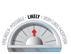
Expected Size?

Travel and Terrain Advice
- Only the most simple non-avalanche terrain free of overhead hazard is appropriate at this time.
- Avoid exposure to overhead avalanche terrain, large avalanches may reach the end of run out zones.
- Numerous large avalanches have run on these layers in well supported, treed terrain.
Avalanche Problem 2: Loose Wet
What Elevation?
Which Slopes?
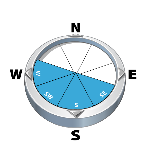
Chances of Avalanches?
Expected Size?

Loose wet avalanches are expected to be problematic again Monday as previously cold snow is subjected to above freezing temperatures and strong solar input.
Travel and Terrain Advice
- Loose avalanches in motion may step down and initiate large destructive slab avalanches.
- Avoid sun exposed slopes when the solar radiation is strong, especially if snow is moist or wet.
Avalanche Summary
On Saturday natural avalanches up size 2.5 were reported on northeast facing features between 1200 m and 1500 m. One small skier triggered avalanche was remotely triggered on a moderately inclined northeast facing alpine feature.
Reports from the last few days include several size 1 to 1.5 persistent slab avalanches that were triggered remotely (from a distance) with slabs 30 to 100 cm in depth. Both the early January and mid-December surface hoar layers were noted as failure planes. These reports all came from the south of the region.
Considerably more avalanche activity has been reported from the adjacent North Columbias, where numerous persistent slabs and storm slabs have recently been observed running naturally and with remote triggers up to size 3.0 with slab depths from 30 to 100 cm. This activity has been observed on all aspects and elevation ranges, although the deeper avalanches running on the mid-December surface hoar have been at treeline and below.
Snowpack Summary
The last series of storms left 20 to 50 cm of snow in their wake with more snow falling in the south of the region. Winds from a wide variety of directions have formed wind slabs in northeast through south facing alpine and upper treeline elevation bands.
This snowpack is currently quite complex, and there are three active Persistent Weak Layers (PWL) that we are monitoring.
The first PWL is known as the early January interface, it is 20 to 50 cm below the surface. It is composed of surface hoar on sheltered slopes as well as sun crust on steep solar aspects. It is thought to be widespread at all elevations bands and has produced numerous recent large avalanches.
The next PWL is the mid-December facet/surface hoar/crust combination which is now buried 50 to 80 cm deep and is most problematic at and below treeline. This interface is not thought to be present in the alpine.
The most deeply buried PWL is the late November rain crust. It is down 70 to 100 cm below the surface and has been less reactive in recent snowpack tests but it may still be susceptible to human triggering, especially in alpine terrain features with a thin or widely variable snowpack.
Weather Forecast
The normal decrease in temperature with height has once again been replaced by an inversion. This classical pattern allows for cooler air to remain in the valleys while alpine temperatures rise to a degree or two above freezing. This setup should stick with us until Tuesday when warm air is expected to begin mixing into the valleys as an offshore front impacts the coast. The interior should remain mostly dry until a more robust system hits the south coast late Wednesday with precipitation spilling into the interior on Thursday.
MONDAY: Scattered clouds in the morning, clearing throughout the day, freezing level at valley bottom with above freezing temperatures between 1600 m and 3300 m, moderate south/southeast wind, no snow expected.
TUESDAY: Increasing cloud cover, freezing level at valley bottom with above freezing temperatures between 800 m and 2000 m, moderate south wind, no snow expected during the day, 1 to 10 cm possible Tuesday night
WEDNESDAY: Broken cloud cover, freezing level at valley bottom, rising to 1500 m in the afternoon, moderate to strong southerly wind, trace of snow possible.
Avalanche Forecasts in your Inbox
Avalanche Canada has switched to an RSS feed for its daily forecasts. This is a much more flexible method that allows automatic delivery to your email inbox, or to an RSS reader of your choice.
What are RSS feeds?
RSS (Really Simple Syndication) is a popular standardized file format allowing up-to-date delivery of web-based content. RSS feeds enable you to receive content updates from websites, delivered to your email through an RSS aggregator (such as blogtrottr.com) or viewed through applications called RSS readers (such as feedly.com).
Set up an RSS feed for your email:
Select a RSS aggregator
- Cariboos URL:
http://www.avalanche.ca/api/forecasts/cariboos.rss - Copy the url and paste it into the appropriate field of your RSS aggregator.
- Fill in your email address.
- Voila! Watch the Avalanche Canada forecast roll into your inbox.
Forecast Disclaimer
Avalanche Canada's Public Avalanche Bulletin, and other information and services provided by Avalanche Canada, are intended for personal and recreational purposes only.
**THIS INFORMATION IS PROVIDED "AS IS" AND IN NO EVENT SHALL THE PROVIDERS BE LIABLE FOR ANY DAMAGES, INCLUDING, WITHOUT LIMITATION, DAMAGES RESULTING FROM DISCOMFORT, INJURY, OR DEATH, CLAIMS BY THIRD PARTIES OR FOR OTHER SIMILAR COSTS, OR ANY SPECIAL, INCIDENTAL, OR CONSEQUENTIAL DAMAGES, ARISING OUT OF THE USE OF THE INFORMATION.**
The user acknowledges that it is impossible to accurately predict natural events such as avalanches in every instance, and uses the data in this bulletin with this always foremost in mind. The accuracy or reliability of the data is not guaranteed or warranted in any way and the Providers disclaim liability of any kind whatsoever, including, without limitation, liability for quality, performance, merchantability and fitness for a particular purpose arising out of the use, or inability to use the data.
Three distinct persistent weak layers in our snowpack have produced numerous large human triggered and natural avalanches over the last few days. Continued warm temperatures Monday may allow for ongoing natural avalanche activity at upper elevations.