Avalanche Forecast
Avalanche Bulletin - Banff, Yoho, and Kootenay National Parks

Avoid all avalanche terrain including crossing runout zones at valley bottom. Natural activity will likely taper over the next couple of days, but human triggering will be as touchy as it gets.
Avalanche Problem 1: Persistent Slabs
What Elevation?

Which Slopes?

Chances of Avalanches?

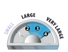
Expected Size?
Travel and Terrain Advice
- Watch for whumpfing, hollow sounds, shooting cracks or recent avalanches.
- Avoid all avalanche terrain.
Avalanche Problem 2: Storm Slabs
What Elevation?
Which Slopes?
Chances of Avalanches?
Expected Size?

There are storm slabs up to 1m thick on many aspects and elevations from the big storm on Thursday. These will be highly sensitive to triggering and once initiated, can step down to the deeper persistent layers causing very large avalanches.
Travel and Terrain Advice
- If triggered the storm slabs may step down to deeper layers resulting in large avalanches.
Avalanche Summary
Another widespread cycle Thursday to size 3.5 (what we could see) . These were failing on the above mentioned weak layers. Explosive control was producing size 3 avalanches up to 150cm deep with just the explosive hitting the slope. Most of these avalanches are traveling far into the valley bottom which should be a concern for all users.
Snowpack Summary
Thursdays storm dropped 30 - 50cm with variable winds. This combined with other recent snow has overloaded the 3 main mid pack concerns which are the Jan 16th, Jan 6th, and Dec.15 weak layers. These are a mix of facets, crusts and surface hoar and can be found 70cm to over 150cm deep in the snowpack and are currently producing very easy results.
Weather Forecast
The epic storm has ended and we will see a few "normal" days of weather. -15 to -18C in the alpine Friday with light winds and mainly clear skies and no additional snow.
Avalanche Forecasts in your Inbox
Avalanche Canada has switched to an RSS feed for its daily forecasts. This is a much more flexible method that allows automatic delivery to your email inbox, or to an RSS reader of your choice.
What are RSS feeds?
RSS (Really Simple Syndication) is a popular standardized file format allowing up-to-date delivery of web-based content. RSS feeds enable you to receive content updates from websites, delivered to your email through an RSS aggregator (such as blogtrottr.com) or viewed through applications called RSS readers (such as feedly.com).
Set up an RSS feed for your email:
Select a RSS aggregator
- Avalanche Bulletin - Banff, Yoho, and Kootenay National Parks URL:
http://www.avalanche.ca/api/forecasts/banff-yoho-kootenay.rss - Copy the url and paste it into the appropriate field of your RSS aggregator.
- Fill in your email address.
- Voila! Watch the Avalanche Canada forecast roll into your inbox.
Forecast Disclaimer
Avalanche Canada's Public Avalanche Bulletin, and other information and services provided by Avalanche Canada, are intended for personal and recreational purposes only.
**THIS INFORMATION IS PROVIDED "AS IS" AND IN NO EVENT SHALL THE PROVIDERS BE LIABLE FOR ANY DAMAGES, INCLUDING, WITHOUT LIMITATION, DAMAGES RESULTING FROM DISCOMFORT, INJURY, OR DEATH, CLAIMS BY THIRD PARTIES OR FOR OTHER SIMILAR COSTS, OR ANY SPECIAL, INCIDENTAL, OR CONSEQUENTIAL DAMAGES, ARISING OUT OF THE USE OF THE INFORMATION.**
The user acknowledges that it is impossible to accurately predict natural events such as avalanches in every instance, and uses the data in this bulletin with this always foremost in mind. The accuracy or reliability of the data is not guaranteed or warranted in any way and the Providers disclaim liability of any kind whatsoever, including, without limitation, liability for quality, performance, merchantability and fitness for a particular purpose arising out of the use, or inability to use the data.
Three weak layers exist in the mid snowpack: Jan 16, Jan 6, and Dec 15. All are a mix of sun crust, surface hoar and facets depending on the aspect and elevation. These layers are very sensitive to triggering both naturally and by human triggering.