Strathcona Provincial Park, Della Falls Trail - June 19-21, 2021
Vancouver Island, British Columbia, Canada

Jun 22, 2021
I just returned from a three-day backpacking trip guiding four enthusiastic ladies on the Della Falls Trail in Strathcona Park. Our objectives were to ride the Della Falls Water Taxi and hike to Della Falls Main Camp on day one, explore the Love Lake Trail as a side trip on day two, and hike back out to the dock for the water taxi pickup on day three. Highlights included epic summer solstice weather, good route conditions, a team keen on learning backpacking skills and wilderness navigation, and spectacular views. Memorable features included Della Falls in full flow, Big Interior Mountain, Nine Peaks, Mount Septimus, Mount Rosseau, and numerous other Vancouver Island peaks far off in the distance.
Weather
The forecast was for sunny skies and extreme heat for the duration of our trip. Day one and day two were cloudier and cooler than forecasted, and day three was sunny and hot as forecasted. Temperatures ranged from a nighttime low of 8.1ºC at 570 m in our camp along the side Drinkwater Creek, to a daytime high of 27.9ºC at 100 m along the shady shores of Great Central Lake. There was no precipitation and it was mainly calm except for a few hours of afternoon katabatic winds.
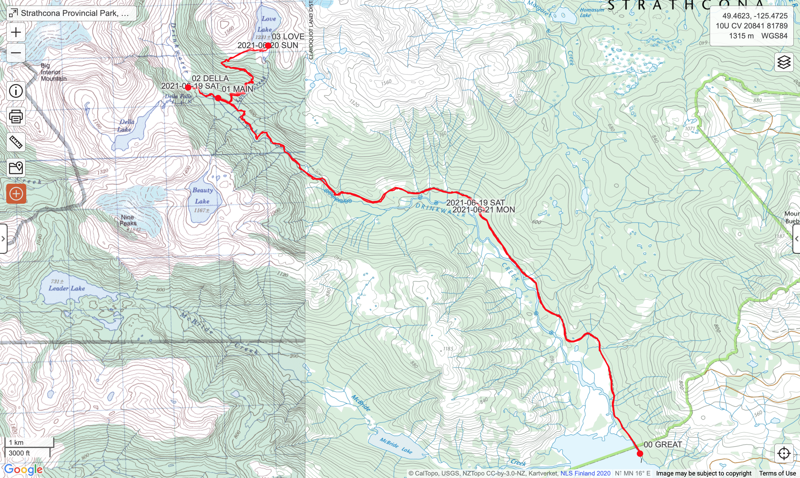
Route
After a smooth ride on the Della Falls Water Taxi across Great Central Lake, we hiked the first 7.5 km on an old industrial road while gently gaining 100 m gain up to Margaret Creek. The next 7.5 km was rougher and included a bit of road grade mixed in with single track, washouts, a few bridges, a cable car, and a 370 m gain up to the Della Falls Main Camp. Our side trip up the Love Lake Trail was 4 km each direction, with an 800 m gain up into the subalpine plateau and cirque below Mount Septimus and Mount Rosseau. The snow line started at 1250 m and was 3-4 m deep in places. We got lucky and hiked across a supportive snow pack in the morning but by the early afternoon it was quickly turning to mush and post-holes were more common. Love Lake was mostly frozen and just starting to open up in a few pools under the hot sun. No swimming!
Wildlife
We saw bear sign, but no bears were viewed. Wildlife viewing was limited to regenerating second growth trees, beautiful old growth temperate rainforest and subalpine ecosystems, frisky birds, and some fresh wildflowers. Birds included early rising hermit thrushes, varied thrushes, robins, Pacific wrens, chickadees, sapsuckers, and a baby pileated woodpecker. Wildflowers included tiger lilies, red columbine, Queen’s cup, vanilla leaf, salmonberries, thimbleberries, arnica, buttercup, pond lilies, and skunk cabbage. Mosquitos were abundant from the trailhead dock up to Margaret Creek. Bring a head net!
Hazards
Besides the hungry mosquitos, sun exposure and dehydration were a concern. Sunglasses, a brimmed hat, sun screen, and frequent water refills were mandatory. The subalpine terrain above 1250 m was snow-covered and route finding was part of our learning objectives. Wilderness navigation skills were required to stay on the route. The rapidly melting and softening snowpack will eventually get too thin to be supportive. Post-holing around big car-sized boulders would be a cause for concern. Stay safe!
Mike Blake
ACMG HG
mbguiding.ca